In 1663 Charles II issued a charter to eight of his favorites, called Lord Proprietors, for land that included the vast territory south of Virginia. Their attempt to set up a feudal society in this area, called Carolina, however, resulted in chaos and rebellion. By 1729 the proprietor's heirs had the land taken back by King George II, who then eased requirements for land purchases and set off quite a boom in settlers moving to North Carolina. Most of the early settlers came from Virginia, moving south to find room for more land or to just find a place to get started. My four time great-grandfather was one of those settlers. (1)

Title: A new map of Carolina
Date Published: circa 1690
Creator - Individual: Lea, Philip, fl. 1683-1700.
Place of Publication: London
Publisher: Philip Lea
University of North Carolina at Chapel Hill
This item is presented courtesy of the North Carolina Collection at the University of North Carolina at Chapel Hill for research and educational purposes. Prior permission from the North Carolina Collection is required for any commercial use.
Bertie County was formed in 1722 right in the middle of these fertile lands. Pronounced Burr-Tee, Bertie County is bounded on the east by the Chowan River, and on the south by the Roanoke River. The Cashie (Ca - shy or Cash - i) River begins and ends in Bertie County. One description of the Cashie goes as follows ..."60 miles of blackwater, only about 25 miles of it navigable, that winds through Bertie County before emptying into Bachelor Bay and Albemarle Sound. What the river lacks in length it makes up for in depth, with spots up to 80 feet deep. Though not as large or well known as the Chowan River to the North or the Roanoke to the south, it was a major transportation artery before railroads and highways." (2)

North Carolina State Map - North Carolina Department of Transportation
http://dotw-xfer01.dot.state.nc.us/imgdot/DOTCountyMaps/PDFs/Bertie_CountyMap_Sheet01_Final_web.pdf
So, besides the fertile land that this area offered, the rivers offered the same for transportation as super highways do today, a fast, efficient way to transport people, merchandise, produce, crops, etc. To move these various items in and out of the county via the river-ways, they needed places to facilitate this movement. Landings or wharves, where ships could dock and unload or load, were constructed along the rivers at strategic locations. As one historian explained it, ..."remote landings were key points for shipping and trade at plantations and large farms along the river during the 1700s."(3)
Keep this in mind as we go forward. These landings will be important factors in establishing Bertie County and also important to my ancestors.

Bertie County, North Carolina
http://en.wikipedia.org/wiki/Bertie_County,_North_Carolina#/media/File:Map_of_Bertie_County_North_Carolina_With_Municipal_and_Township_Labels.PNG
Fertile soil, deep running rivers and very little population (maybe around 2000 in the county) presented a great opportunity for settlers moving to Bertie County. They could make a living through agriculture, fisheries, or import/export. The river allowed their goods to be shipped into the county by way of the Cashie and then transported out to the rest of the county or into other counties for distribution. Likewise goods produced in the county could easily be shipped out to other colonies or to areas around the world via these landings.
I am going to go back over a little bit of the family that I wrote about last time, because I want to fill in a few new details. Anthony Armistead (1691-1738) first married Jane, last name unknown, and had a son John, probably around 1721. Jane died and Anthony then married Margaret Benit and had William (1730-1791), Benit, (1732-?), and Anthony (1736-abt. 1792). Anthony Armistead, Sr. died in 1738 and his widow, Margaret, later married Edward Morgan, who then became guardian of her children. William was 8 years old, Anthony 2 and the oldest, John was about 17. Then, in 1745, the records show "that on the motion of John Armistead" Edward Morgan was removed from guardianship of William Armistead, "son of Anthony, deceased" and in Morgan's place the court appointed John Armistead. I believe this John was William's older brother. William was now 15 and John about 24. (4)

http://ushistoryimages.com/north-carolina-colony.shtm
In 1754 a deed was granted to John Armistead for 417 acres on Roanoke River in the Northwest corner of Northampton County, North Carolina. (Now it is in Warren County due to boundary changes.) My thought here is that William probably accompanied John to North Carolina. On the 3rd of May 1755, John Williams conveyed to "William Armistead of Northwest Parish Northampton County" 150 acres. I believe this to be my ancestor, because this is the same location we saw for John. In the publication "Genealogies of Virginia Families" it states, "It will be noted that William appeared upon the records of North Carolina almost simultaneously with John."(5)
A year after this purchase in, 1755, William turns up a few miles southeast in Bertie County when we find a record showing he was married, March 18, 1756, to Sarah Jordan. She is the daughter of Joseph Jordan and Ruth (Speight) Jordan who lived in Bertie County. (6) I wonder how these two met? Did their families know each other from Virginia? Did William move to Bertie County because Sarah was there or did they meet after he moved there? I don't know how it came about but I do know they were married.
I have spent very little time researching my Jordan line, but I do know Joseph and Ruth Jordan were prominent land owners and early settlers. I think William had some inheritance to start with and was a property owner, but I guess it never hurts to marry well, right?
Bertie County records state that Joseph Jordan built a house in Bertie County in the early 1700's. One date says around 1713, but another says 1738, which seems more likely. I am not certain if the Joseph Jordan above is the one that built it or if it might have been his father or son. (He had a son named Joseph and I do not know his father's name.) Anyway, the house is still there today and is known as the Jordan Plantation House. Fire destroyed the inside of the house in 1925 but the brick exterior survived. The property stayed in possession of descendants and the inside was eventually restored. In 1966 it was still owned by a descendant of Joseph Jordan and in use as a country home. Of course lots could have change since then. I hope it is still in the family. (7)

Jordan House, ca. 1738.
Comprehensive Architectural Survey of Bertie County Final Report
Submitted by: Laura Ewen Blokker
Southeast Preservation, P.O. Box 1022, Elm City, NC 27822
April 30, 2010
The book where I obtained information about this house (See reference at bottom of page.) has a wonderful description of the home that I have to share with you here. Mrs. Edythe Smith Dunstan published this book in 1966 and wrote the description as follows:
"Jordan Plantation house, located a few miles south of Windsor, N.C, just off the Cedar Landing Road, was built about 1700 by Joseph Jordan, great-great-great-great-grandfather of the author's husband, Frederick Miller Dunstan, Junior. It is said to be a fine example of an English gentleman's 'fair county seat'. Although the exact date of the house is not known, it resembles the 17th Century houses built in Virginia between 1650 and 1700, particularly the John Rolphe House in Surrey, VA., built in 1652. A fine paneled interior was destroyed in 1925 when the house burned leaving only the thick brick walls standing. It is constructed of ruddy brick, laid Flemish Bond style above the ground level and English bond below ground, with rubbed bricks at the water table. It stands one and a half stories tall and rests upon a high basement, pierced by arched windows.
There is a large interesting brick fireplace with herring -bone fireback, in the main hall, and there are large corner fireplaces in the dining hall and small nearby sitting room. All sleeping rooms are on the upstairs level. Tradition says that the date of 1713 could be seen carved on a basement wall on a brick prior to the fire's destruction.
The plantation is now owned by Mr. and Mrs. Francis Gillam (nee Martha Rascoe) who are descendants of the Jordan Family. The house is in a fine state of repair and is maintained as their country house, where many social gatherings are enjoyed by friends." (8)
Another record from a year later is a document titled, "A List of Taxables, taken by Joseph Jordan for ye Year 1757". Joseph Jordan is listed with sons Isaac and William, and four slaves as taxables. (Adult males and all slaves were taxed.) There were a total of 59 taxables in Joseph's area of responsibility. Next district over, John Yeats includes on his list of taxables, William Armistead and an apprentice, Moss Armistead, and four slaves. Next one down the list was Anthony Armistead with only himself as taxable. I believe this was my William and his younger brother Anthony. Yeats' list had a total of 55 taxables. (9)
Also, in 1757 William and Sarah had their first child, John.


List of Taxables in Bertie County, NC
http://files.usgwarchives.net/nc/bertie/census/tax1757.txt
In 1758 William's bother, Anthony, gave bond to marry Mildred Rhodes and in 1759 William and Sarah had their first daughter, Elizabeth. In this year William also purchased 294 acres of land from his father-in-law, Joseph Jordan, located on the south side of the Cashie River in Cashie Neck called "Beauties Brother". (10)(11)

Individual Report for William Armistead by Family Tree Maker.
A second son, William, came along in 1762, followed by Anthony in 1764. Another land purchase was made in 1765 for 124 acres, again on the south side of the Cashie River. Additional purchases would be made over the years.
As William was building his large land holdings, he and Sarah were also building a larger family . Child number five was Robert, born in 1767, number six, Sarah, in 1770. No offense to the other children but my favorite child came along as number seven in 1775. Born during the year the American Revolution started, Jordan, is my three times great-grandfather.
William and Anthony were active in Bertie County during these early years. Anthony was on the North Carolina Assembly and he and William were active in founding the town of Windsor and making it the county seat. Established in 1766, the town was laid out in 1768 on 100 acres acquired from William Gray and located on the Cashie River. The location was originally known as Gray's Landing.

Repository: Southern Historical Collection, Wilson Library, University of North Carolina at Chapel Hill
Date Published: February 17, 1806
Date Depicted: 1806
Creator - Individual: Bryan, Joseph W.
Abstract: Manuscript map of Windsor, N.C., showing numbered lots, streets and the names of some landowners.
Map Type: ManuscriptProperty
Details: Landowners
Subject - Geographic: Windsor (N.C.) -- Maps.
http://dc.lib.unc.edu/cdm/compoundobject/collection/ncmaps/id/3452/rec/1
Named for the Windsor Castle in England, the town of Windsor was finally chosen as county seat in 1774. This location was chosen for it's location on the Cashie where a landing could be established (Remember what I said above?) for ships to unload merchandise arriving from the West Indies and other places and then distribute it inland to all parts of the county by wagon. Windsor soon became the county's leading agricultural and mercantile trading center. Tar, turpentine, lumber, barrel staves, shingles, timber, corn, wheat, and tobacco, were among the largest exports. There were also fishery operations in the county. (12)

“Historic Windsor:
Listed on the National Register of Historic Places, Windsor was first
known as Gray’s Landing in the early 1700s.
Over 250 years of history can be found in its Historic District,
including the Bertie County Courthouse, (c.1887) and the Freeman Hotel
(c.1840), a Greek Revival building and currently the home to the Windsor-Bertie
County Chamber of Commerce. Other sites
include St. Thomas Episcopal Church (c.1839), The Gray-Gillam and J.B. Gillam
Houses (c.1790), and Windsor Castle (c.1858).” From the Windsor Chamber of Commerce site at: http://www.windsorbertiechamber.com/
I think most of William Armistead's large land holdings were located on the Cashie River, southeast of Windsor, not too far from where it winds it's way to the Albermarle Sound. This was a very advantageous location for William's property. More to come on that later.
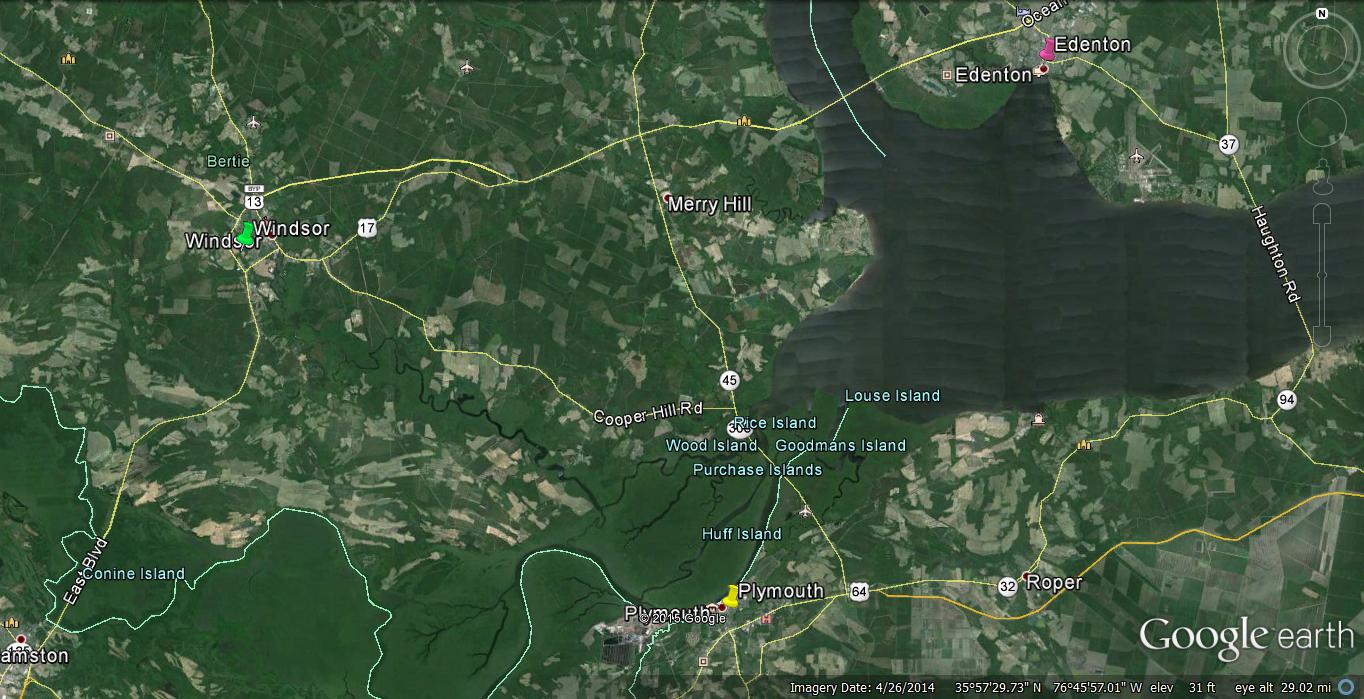
Google Earth Map of a section of Northeast North Carolina, including Windsor, Plymouth, and Edenton.
https://www.google.com/maps/place/Bertie+County,+NC/@35.9186954,-76.7756051,57938m/data=!3m1!1e3!4m2!3m1!1s0x89afa3ca27a02cb3:0x4ee346fe7765ab49!6m1!1e1
Here you can get a good overview of Windsor to the upper left, Edenton to the upper right, and Plymouth in the lower middle. The Cashie River flows from Windsor southeast toward the Roanoke River where Plymouth is located. Albermarle Sound is in the center right. Armistead children would eventually expand into these other cities and surrounding counties. This overview is great for getting a better understanding of how the location among the rivers shaped the direction of commerce in Bertie, as well as all the surrounding counties.
So by 1775, William and Sarah had a family of seven children and large land holdings. But the years 1775 and 1776 will prove to be a turning point in the lives of the colonists and the 13 Colonies. Each household will have to decide if they will be loyal to the Crown and mother country, Great Britain, or follow new leaders in the 13 Colonies that are preaching revolution and independence.
What will be their choice?
My next post will be about the build up to the start of The Revolutionary War. If you are not interested in history you might want to skip it because there will only be American History in it, no family history. I decided it was too much to put in one post, so instead of including it here, I am dividing it and will post that portion soon. I hope you'll be back.
References:
1) http://www.learnnc.org/lp/editions/nchist-colonial/1665
2) http://ncseagrant.ncsu.edu/coastwatch/previous-issues/2010-2/summer-2010/people-places-hidden-history-cashie-reveals-backwater-wharf
3) http://ncseagrant.ncsu.edu/coastwatch/previous-issues/2010-2/summer-2010/people-places-hidden-history-cashie-reveals-backwater-wharf
4) McGhan, Judith, indx., Genealogies of Virginia Families, From Tyler's Quarterly Historical and Genealogical Magazine, IV Volumes, Original Article Contributed by William B. Newman, Washington, D.C., Baltimore, MD, Genealogical Publishing Co., Inc., Vol. I, pg34.
5) Ibid.
6) Ford, Carol Lee, indx., Genealogies of Virginia Families, From the William and Mary College Quarterly Historical Magazine, V Volumes, Baltimore, MD, Genealogical Publishing Co., Inc., Vol. I, pg 138-139.
7) Dunstan, Edythe Smith, The Bertie Index, For Courthouse Records of Bertie County, North Carolina, 1720-1875, Edythe Smith Dunstan, 1966, Illustration #3.
8) Ibid.
9) http://files.usgwarchives.net/nc/bertie/census/tax1757.txt
10) Ibid., Ford
11) Bradley, Stephen E., Jr.,Dr., abst’d, Early Records of North Carolina, Probates, Administrations, Inventories, Dr. Stephen E. Bradley, Jr., Vol. I, pg. 27.
12) http://www.livingplaces.com/NC/Bertie_County/Windsor_Town/Windsor_Historic_ District.html
Other References Used For General Information:
http://www.northcarolinahistory.org/encyclopedia/613/entry