Tuesday, December 15, 2015

Armistead Family History #11 - Armisteads in North Carolina

                                                                Revolutionary War


On the 19th of January, 1775, on the eve of the American Revolution, my great-great-great-grandfather, Jordan Armistead, was born on the Armistead Plantation in Bertie County, North Carolina Colony in the British Empire.  In a year and a half he would be living in a different country, the United States of America, and he wouldn't have to move an inch from where he was born to get there.


Patrick Henry's Speech

Description:  Peter F. Rothermel's "Patrick Henry Before the Virginia House of Burgesses", a painting of Patrick Henry's "If this be treason, make the most of it!" speech against the Stamp Act of 1765

Date:  1851
Source:  http://cgfa.sunsite.dk/r/p-rotherm2.htm
Author:  Peter F. Rothermel (1817–1895)
https://commons.wikimedia.org/wiki/File:Patrick_Henry_Rothermel.jpg

Jordan Armistead was born just 2 months before Patrick Henry declared "Give me Liberty or Give me Death", and five months before George Washington was appointed Commander-in-chief of the Continental Army. William Armistead, Sr. was 45 years old at the time of Jordan's birth in 1775 with all 7 of his children (at that time) living at home.  Their ages ranged from 17 to new born.


This portrait of Washington was painted in 1772 byCharles Willson Peale, and shows Washington in uniform as a colonel of the Virginia Regiment. The original hangs in Lee Chapel at Washington and Lee University in Lexington, Virginia. It is the earliest known depiction of Washington.

Charles Willson Peale - Washington-Custis-Lee Collection, Washington and Lee University, Lexington, Virginia And athttp://www.americanmilitaryhistorymsw.com/blog/536357-washingtons-mission/ Painting showing George Washington during his French & Indian War days. by Charles Volkmar, 1874, after Charles Willson Peale (Mount Vernon Ladies' Association)

http://www.mountvernon.org/george-washington/french-indian-war/ten-facts-about-george-washington-and-the-french-indian-war/

I have not found any records indicating William Armistead Sr., served during the Revolutionary War, but it does seem obvious to me that the Armisteads supported the rebel government over the British government.  It is possible he provided some type of service in the form of supplies, etc. Many colonists did and I found reference to other Armisteads that were recognized for doing just that. I know many Armisteads served in the Revolutionary War, but I have found only two Armisteads from North Carolina.  In the book Roster of Soldiers from North Carolina in the American Revolution: With an Appendix Containing a Collection of Miscellaneous Records, the only two Armisteads listed are Anthony Armistead and Westwood Armistead. (1)  They are probably related in some way to my ancestors, but I am sure they are not direct ancestors. It seems to me the timing was not right for Jordan (too young) or for William, Sr. (too old, with many young children) to have fought in the war.  I do have other direct lines that have been documented to have fought in the war. Maybe I can get into those lines in some future post.


Title:  A new map of Carolina
Date Published:  circa 1690
Creator - Individual:  Lea, Philip, fl. 1683-1700.
Place of Publication:  London
Publisher:  Philip Lea
University of North Carolina at Chapel Hill
North Carolina Maps is made possible by the Institute of Museum and Library Services under the provisions of the Library Services and Technology Act as administered by the State Library of North Carolina.
This item is presented courtesy of the North Carolina Collection at the University of North Carolina at Chapel Hill for research and educational purposes. Prior permission from the North Carolina Collection is required for any commercial use.

During the years from 1775 to the end of the war in 1783, William and Sarah Armistead continued to thrive in growing their family and their businesses.  After Jordan's birth in 1775, their eighth child, another girl, Mary, was born in 1777.  Stark (or Starkey) was born in 1780 and the last two children to be born were twins, Thomas and Priscilla, in 1783.  Thomas only lived a short time before he died on Nov. 24, 1783.

The county records of these years in Bertie County reflect the fact that both William and his brother Anthony were important citizens of Bertie County.  They witnessed land transactions, were appointed overseers of roads, and presided over courts, as well as served on juries and grand juries.  They witnessed wills and helped divide estates.  On one transaction in 1783, Anthony was described as "Justice of ye Peace". (2)


Map of the Colonies in 1775

"Map of territorial growth 1775" by Cg-realms; adapted from a scan from the National Atlas of the United StatesThis vector image was created with Inkscape. - Adapted from National Atlas of the United States scan uploaded by Kooma using File:Blank US Map.svg as a template. Licensed under Public Domain via Commons - https://commons.wikimedia.org/wiki/File:Map_of_territorial_growth_1775.svg#/media/File:Map_of_territorial_growth_1775.svg


For the Thirteen Colonies these same years of 1775 - 1783 encompassed a time in our history where tremendous challenges faced the Colonists.  It was a time of great change that ultimately led to the birth of a new and free nation where "all men were created equal", unless you were a slave or female and that "equal" part would take many more years to get spread around.

In January of 1776 Thomas Paine, published his pamphlet "Common Sense" and in it he wrote about America's right to create a democratic and free nation.  He sold hundreds of thousands of copies of his pamphlets, which helped win the support of the Colonists for the cause of American Independence. (3)

As events were unfolding and escalating, the second Continental Congress appointed a committee to put together a document regarding their intentions.  This document, written by Thomas Jefferson, was received from the appointed committee, and approved by the Congress.  This document was The Declaration of Independence. (4)


"United States Declaration of Independence" 

by original: w:Second Continental Congress; reproduction: William Stone - numerous. Licensed under Public Domain via Commons - https://commons.wikimedia.org/wiki/File:United_States_Declaration_of_Independence.jpg#/media/File:United_States_Declaration_of_Independence.jpg, https://en.wikipedia.org/wiki/United_States_Declaration_of_Independence#/media/File:United_States_Declaration_of_Independence.jpg

After publication of the Declaration of Independence, there was no turning back and the Revolutionary War grew in intensity.  On Dec 25th of 1776 General Washington and his troops crossed the Delaware River at night and defeated 1400 Hessian troops in the first Battle of Trenton. Then on Jan. 3, 1777, they defeated British General Charles Cornwallis at Princeton, New Jersey. European nations would begin to take notice of the Americans. (5)


Washington Crossing the Delaware

"Emanuel Leutze (American, Schwäbisch Gmünd 1816–1868 Washington, D.C.) - Washington Crossing the Delaware - Google Art Project" by Emanuel Leutze - KAHKUjVORM5STw at Google Cultural Institute, zoom level maximum. Licensed under Public Domain via Commons - https://commons.wikimedia.org/wiki/File:Emanuel_Leutze_(American,_Schw%C3%A4bisch_Gm%C3%BCnd_1816%E2%80%931868_Washington,_D.C.)_-_Washington_Crossing_the_Delaware_-_Google_Art_Project.jpg#/media/File:Emanuel_Leutze_(American,_Schw%C3%A4bisch_Gm%C3%BCnd_1816%E2%80%931868_Washington,_D.C.)_-_Washington_Crossing_the_Delaware_-_Google_Art_Project.jpg


On June 14, 1777, the Stars ands Stripes was adopted as the national flag and on Nov. 15, 1777, the Articles of Confederation and Perpetual Union were adopted by the Continental Congress.  In December of 1777 John Adams and Benjamin Franklin were appointed Commissioners and sent by Congress to France to convince the French government to recognize the independence of the Thirteen Colonies and to agree to a treaty on alliance and commerce. Their success in France was a turning point in the war, but the full benefit of the treaty would take time to materialize. (6)

Going into the winter of 1777 the Colonial forces suffered through battles at Brandywine and Germantown without a victory and then British forces captured Philadelphia. As winter set in, George Washington took his ragged and weary group of 11,000 men that comprised the Continental Army into Valley Forge for the winter. Upon arrival many of the soldiers lacked adequate clothing and many had no shoes.  As they entered Valley Forge, they left bloody footprints in the snow. During the army's stay there, Friedrich von Steuben of the Prussian Army was directed to join Washington at Valley Forge to train the soldiers.  In February of 1778 von Steuben began drilling the army in an attempt to turn it into a fighting unit.  Also in February, France signed the treaty of Amity and Commerce with the United States, officially recognizing the new nation.  After a miserable winter at Valley Forge, the prospect of French assistance boosted morale. (7)


Painting of Washington at Valley Forge.

Description:  George Washington and Lafayette at Valley Forge.

Date:  1907
Source:  http://www.loc.gov/pictures/item/91792202/
Author:  John Ward Dunsmore
Licensing:  This media file is in the public domain in the United States. This applies to U.S. works where the copyright has expired, often because its first publication occurred prior to January 1, 1923. See this page for further explanation.

In June of 1778 British forces left Philadelphia to reinforce their troops in New York City.  This action came as a direct response to French involvement in the war.  But the war continued to go poorly for the Colonists.  Georgia was lost to British control in December of 1778 at the first battle of Savannah. (8)

In June of 1779 the American General, Benedict Arnold, turned traitor against the American cause and began fighting with the British. George Washington and his troops spent this winter in Morristown, New Jersey. (9)

The war continued to go against the Colonists in 1780 as British troops took control of Charleston, SC on May 12th, but on July 11th, the arrival of French troops on American soil at Newport, Rhode Island brought hope of good things to come.  In October things finally started looking better as the "over-mountain men" defeated British Loyalists at the Battle of Kings Mountain in South Carolina, and killed the British Major General Patrick Ferguson. This reversed the downward trend in the south and that victory was followed in January of 1781 with a victory at Cowpens, South Carolina. In March American forces under Major General Nathaniel Green were defeated at the Battle of Guilford Courthouse in North Carolina, but the British victory proved to be a costly one in terms of lives lost. As it turned out, this battle was the opening battle of the campaign that led to Yorktown and the end of the war. (10)


1st Maryland Regiment holding the line at the Battle of Guilford

Battle of Guilford Courthouse, 15 March 1781 General Nathaniel Greene observed as the veteran en:1st Maryland Regimentthrew back a British attack and countered with a bayonet charge. As they reformed their line, William Washington's Light Dragoons raced by to rescue raw troops of the en:5th Maryland Regiment who had buckled under a furious assault of British Grenadiers and Guards Source: downloaded from Prints and Posters: Soldiers of the American Revolution, Center of Military History. Access date: June 1 2006.


Original uploader was Oldwildbill at en.wikipedia - Transferred from en.wikipedia

The Guilford Courthouse battle was about 170 miles to the west of Bertie County, North Carolina. This seems to be the closest major battle to Bertie County and the Armisteads.  Cornwallis and his troops did go through Halifax in Halifax County (about 40 miles to the northwest) on their way to Virginia in 1781.  Local militia in that county tried to harass his troops and stop them but they were only successful in killing a few men before Cornwallis moved on into Virginia, headed to Yorktown. (11)  From what I can tell, there were not any troop movements in Bertie County, probably because there were several large rivers to cross and lots of swamp land that would have had to be negotiated.

The battle at Guilford was followed on May 22 by Major General Greene and Harry "Light-horse" Lee leading the Continental Army in a siege of the British at Ninety-Six, South Carolina.  The Continental troops were repulsed and were eventually forced to withdraw on June 18th. (12)

Although the Continental Army suffered losses and didn't "win" a lot of these battles, the constant pressure and harassment by the Continental forces started to have an effect on British forces.  Lord Cornwallis began moving his weary troops toward the Virginia coast so he could maintain his sea routes and communications with the large force of General Henry Clinton in new York City.  He settled in at Yorktown in August of 1781.  Meanwhile General George Washington and the French Count de Rochambeau joined forces near Williamsburg, VA.  Washington had previously instructed Marquis de Lafayette and his American force of 5,000 to block any land escape route by Cornwallis out of Yorktown. (13)


The First meeting of Washington and Lafayette, Philadelphia, Aug. 3rd, 1777·

Creator(s): Currier & Ives.,·

Date Created/Published: New York : Published by Currier & Ives, c1876.· Medium: 1 print : lithograph.·
Collections:  Popular Graphic Arts
Date:  1876
Source:  http://www.loc.gov/pictures/item/2006691579/ http://memory.loc.gov/pnp/cph/3b50000/3b50000/3b50200/3b50200r.jpg
Author:  Currier & Ives
Licensing:  This media file is in the public domain in the United States. This applies to U.S. works where the copyright has expired, often because its first publication occurred prior to January 1, 1923. 


https://en.wikipedia.org/wiki/Gilbert_du_Motier,_Marquis_de_Lafayette#/media/File:First_meeting_of_Washington_and_Lafayette,_Currier_and_Ives_1876.jpg

On the high seas a very important naval battle at Virginia Capes raged on September the 5th of 1781 between the French Navy and a British fleet under Admiral Thomas Graves.  The French Navy prevented the British from breaking through to the coast, where they would have been able to supply crucial reinforcements to Cornwallis.  Instead this allowed a large French fleet of war ships under Count de Grasse to attack the British by sea and completely seal them off. (14)


Plan of the Battle of Yorktown.

Date:  1875

Source:  Goodrich, S. G. (1875). A Pictorial History of the United States. Philadelphia: J. H. Butler & Co., 277.
Author:  S. G. Goodrich
Licensing:  This media file is in the public domain in the United States. This applies to U.S. works where the copyright has expired, often because its first publication occurred prior to January 1, 1923. See this page for further explanation.

https://en.wikipedia.org/wiki/Siege_of_Yorktown#/media/File:Plan_of_the_Battle_of_Yorktown_1875.png 

Washington and Rochambeau's armies joined Lafayette at the end of September 1781 and for two weeks these 14,000 French and American forces, along with the French warships, gradually beat down the British.  On October 19th General Cornwallis surrendered "...7,087 officers and men and 900 seamen along with 144 cannons, 15 galleys, a frigate and 30 transport ships" to Washington's army. (15)


Surrender of Lord Cornwallis
  
Description:  This painting depicts the forces of British Major General Charles Cornwallis, 1st Marquess Cornwallis (1738-1805) (who was not himself present at the surrender), surrendering to French and American forces after the Siege of Yorktown (September 28 – October 19, 1781) during the American Revolutionary War. The United States government commissioned Trumbull to paint patriotic paintings, including this piece, for them in 1817, paying for the piece in 1820.
Artist:  John Trumbull (1756–1843)
Date:  1820, placed 1826
Medium:  oil on canvas
Current location:  Rotunda of the US Capitol Washington D.C.
Source/Photographer:  http://www.aoc.gov/cc/photo-gallery/ptgs_rotunda.cfm
Permission(Reusing this file):  This work is in the public domain in the United States because it was published (or registered with the U.S. Copyright Office) before January 1, 1923.

https://en.wikipedia.org/wiki/Siege_of_Yorktown#/media/File:Surrender_of_Lord_Cornwallis.jpg  
           

Although there would be some battles at sea and other areas later on, the battle at Yorktown was the last major battle and effectively ended the revolutionary War.  Peace negotiations began later in the year and ended on Sep. 3, 1783 with the Treaty of Paris, which formally recognized the United States as a free and Independent nation.

If you love history then you are like me and you can get totally involved in reading and studying the years from the early 1770s to the early 1800s.  So many things were happening.  Of course there is the war itself and the years of battles and the ups and downs of the Colonies, and then, after the war, you have the Continental Congress and the writing of the Constitution, the election of our first president and vice president, etc.  President Washington, in his first term, had to get all the workings of the Federal Government established and up and running.  It is quite amazing how everything actually came together.  All of these men that were involved in events that led up to war, the war itself, and the establishment of the government and our Constitution are such larger than life figures in our history.  Names like Washington, Adams, Jefferson, Madison, Hamilton, Franklin, Monroe, just to name a few, have inspired hundreds of books over the years.  I could write full time on a blog just about these 30 to 40 years and the people that founded our nation and be quite happy.

So, now back to the Armisteads.  I mentioned above the births of the last four children which brought the total to eleven and as I said, Thomas died shortly after birth.  Of the 10 surviving children, Elizabeth was married in 1785 and four others, Mary, Sarah, Robert, and Jordan, were married during the decade of the 1790's.  I do not know when John married but it was possibly during this time as well, maybe in the 1780's as he would have been 33 by 1790.  Anthony Armistead died in 1789, apparently without having married. So, by 1790, William and Sarah had as few as 5 or as many as 7 children still at home.


Bertie County, North Carolina

http://en.wikipedia.org/wiki/Bertie_County,_North_Carolina#/media/File:Map_of_Bertie_County_North_Carolina_With_Municipal_and_Township_Labels.PNG      
                     

William Armistead, Sr. made his will on Jan. 19, 1791.  He must have known he was very sick, because he died a few days later. As I mentioned above, probably at least half of the children were still at home, with the youngest being 7 years old.  There was a lot for Sarah to have to take on by herself.  She did have the older boys to help out, but four children under the age of 16, a plantation, ships, and a fisheries business would have been a very tall order to take over by anyone.

William Armistead, Sr.'s will is below.  It is hard to read the old script but it is very interesting so maybe give it a shot.  If you click on the image it will open up larger.  At least it does for me.


The four pages of the Will of William Armistead Sr.  (With my transcription on the one page at the bottom.)

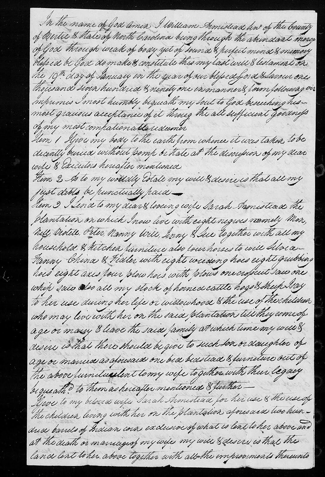
"North Carolina, Estate Files, 1663-1979," index and images, FamilySearch (https://familysearch.org/pal:/MM9.3.1/DGS-004763695_00266?cc=1911121&wc=M9W4-NM9 : accessed 18 February 2015), Currituck County > A > Armistead, William > image 54-57; State Archives, Raleigh.  


William's will and inventory of his estate reflects a wealthy plantation owner with a large amount of land.  But surprisingly to me, he also owned a couple of ships or to be more accurate, schooners.  A schooner "is a type of sailing vessel with fore-and-aft sails on two or more masts, the fore mast being shorter than the main and no taller than the mizzen if there is one.  Originally gaff-rigged..." (16) (I have no clue what that means.)  First used in the 16th or 17 century by the Dutch, these vessels were important in North Carolina because they could sail in shallow waters.  The colonists used schooners to sail up rivers such as the Cashie River, where other type ships could not go.  One of William's schooners was named Priscilla, apparently after his youngest daughter.


A traditional gaff topsail schooner.

Uploaded by:  en.wikipedia user - taken from en.wikipedia at [1]

Taken:   4-JUL-1976, NYC.
Permission details:  This work has been released into the public domain by its author, Scott Rasmussen at the English Wikipedia project. This applies worldwide.In case this is not legally possible:Scott Rasmussen grants anyone the right to use this work for any purpose, without any conditions, unless such conditions are required by law.

Taking a close look at the inventory of his estate, it appears William Armistead was involved in the import and export business, the fisheries business, and the running of a large plantation.  It is fascinating to read what all is listed on his estate inventory.  I included a copy below but to give a few examples besides the two schooners:  a vessel now on the stocks, 2 moses Boats, 1 canoe, 13 hogsheads of West India Rum, 19 bags coffee, 7 1/2 kegs of different color paint, 7 time glasses of 28 seconds each, 4 time glasses of 14 seconds each, 1 two hour glass, 14 3/4 doz wine glasses, dozens of yards of different type of cloth, yards of silk, all types of cooking utensils, all types of dishes, 10 muskets & bayonets, 9 cutlasses, 2 small guns, 10 boarding pikes, 10 cannon guns with carriages, etc., 2 riding chairs, 4 bee hives and bees. Very interesting stuff.  There are eight pages.  Take time to read through them, I think you will find it very interesting.


Inventory of William Armistead's Estate.

"North Carolina, Estate Files, 1663-1979," database with images, FamilySearch (https://familysearch.org/pal:/MM9.3.1/TH-1951-21483-55235-65?cc=1911121&wc=93G9-L2N:183208201,183204102,183331001 : accessed 26 August 2015), Bertie County > A > Armistead, William > image 101-108; State Archives, Raleigh.


There is also listed, 32 Negroes (his slaves), right on the list with all the other property in the inventory. That is pretty hard to read and not cringe.  I know it is the reality of the time and I will not go into a discussion of it here.  This is obviously part of who he was and I have to accept that, but it doesn't mean I have to be proud of it.

For some time now I have been studying the description of William's land purchases and looking at topographical maps to see if I could determine where his land was located along the Cashie River in Bertie County.  Not too long ago, I came across an article online titled: "PEOPLE & PLACES: Hidden History: Cashie Reveals Backwater Wharfs, written by Jerry Allegood.  The URL is:

http://ncseagrant.ncsu.edu/coastwatch/previous-issues/2010-2/summer-2010/people-places-hidden-history-cashie-reveals-backwater-wharf/       

The article is about Bob and Becky Bowling, who live on the Cashie River, and discovered, during a temporary dropping of the river due to high Northwest winds, a previously unknown shipwreck a few feet from their shoreline. Exciting, right?  As they say on TV ads, "But wait, there's more!"  East Carolina University's Program in Maritime Studies researchers came in to examine the site.  Theresa Hicks, an ECU graduate student studied the site as a North Carolina Sea Grant project.  She believes the ship was a part of a wharf or landing and was possibly over 200 years old. These "remote landings were key points for shipping and trade at plantations and large farms along the river during the 1700s" (17)

Another short paragraph about the Bowling site is located at the URL below.  When you get to the website, scroll to the bottom to find the article.

http://inlandseasinstitute.com/projects.aspx

Researchers found a curious thing about this landing.  A ship had been pulled up to shore, stern first, an oddity they had not seen before.  Ships usually enter to the shore bow first.  It appears the ship somehow was used as a part of the wharf. The bow was actually sawed off and the remaining part of the ship was actually fixed in a way that it was used as a part of the wharf.

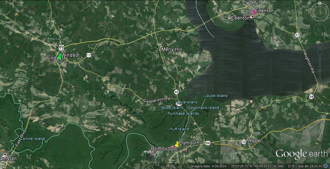
And now the really fun and exiting part.  Theresa Hicks "believes the Bowling's 67 acre tract was part of 750 acres owned in the late 1700s by William Armistead Sr., a wealthy planter and merchant who died in 1791." (18)  Holy Cow!!  That's my ancestor!


Google Maps.  The approximate location of the Armistead Plantation along the Cashie River. 

https://www.google.com/maps/place/Blanchards+Rd,+Windsor,+NC+27983/@35.9332573,-76.8468692,13z/data=!4m2!3m1!1s0x89afa04eb4ebc7e1:0x918f7a6701016093?hl=en


According to the article the original property owned by William Armistead actually had two landings, one at Bowling Farm and another at what today is called Blanchard's Landing.  I don't know when he got into the shipping business but I imagine he either bought land on the river intentionally for that purpose or after being on the river a few years he saw the potential and got into it then. Being located down river from Windsor, the destination for many ships, gave him a prime location to have his own landing and to bring merchandise in and out.  So, if you remembered what I said in my Armistead Post # 9, about how important these landings along the rivers were to the county, and how important they were to my ancestors, well, I guess you get a gold star.


Google Maps.  Obviously my lines do not indicate the exact outline of the plantation, but rather a rough idea of where William Armistead's land was probably located.

https://www.google.com/maps/place/Blanchards+Rd,+Windsor,+NC+27983/@35.9332573,-76.8468692,13z/data=!4m2!3m1!1s0x89afa04eb4ebc7e1:0x918f7a6701016093?hl=en


Ms. Hicks wrote her thesis on plantation wharves and the Armistead wharf is included.   She covers the Bowling Farm (Armistead) wharf starting on page 116.  I recommend you read both the People & Places article and Theresa Hicks discussion of the Armistead wharf.  You can go to this URL to read her paper:

http://thescholarship.ecu.edu/bitstream/handle/10342/3837/Hicks_ecu_0600M_10666.pdf?sequence=1&isAllowed=y

This is a very long post but I hope you enjoyed it.  Finding the article about the Armistead Plantation in Bertie County, NC., was one of the most exciting things I have ever come across and this time period in history has been the subject of many of the books I have read over the years.  So, I really enjoyed researching and putting this one together.

I will take up the Armistead story again next time, starting after William's death in 1791.

References:
(1)  Roster of Soldiers from North Carolina in the American Revolution: With an Appendix Containing a Collection of Miscellaneous Records, Clearfield Company, Inc., Reprinted by Genealogical Publishing Co., Inc., Baltimore, MD, 2003. pg. 571, 589. 
(2)  Bradley, Stephen E., Jr., The deeds of Bertie County, North Carolina, 1772-1785, Bradley, Virginia Beach, Virginia, 1994, pg. 69.
(3) - (15)  http://americasbesthistory.com/abhtimeline1770.html 
(16)   https://en.wikipedia.org/wiki/Schooner
(17)   Allegood, Jerry, PEOPLE & PLACES: Hidden History: Cashie Reveals Backwater Wharfs, Coastwatch,  http://ncseagrant.ncsu.edu/coastwatch/previous-issues/2010-2/summer-2010/people-places-hidden-history-cashie-reveals-backwater-wharf/        
(18)  Ibid.


Sunday, October 25, 2015

Armistead Family History #10


                                                Build Up to the Revolutionary War


In the mid seventeen hundreds events in the colonies and in England started a slow but inevitable slide toward revolution in the colonies.  On " May 28, 1754, George Washington and his troops attacked Fort Duquesne, an initial action of the French and Indian War between the English and French, which began when French forces built and occupied Fort Duquesne in Pittsburgh and did not heed warnings to leave Virgina territory." (1)


French and Indian War-Map

Description:  Map of the French and Indian War
Date:  29 January 2014, 10:21:23
Source:  Own work
Author:  Hoodinski

George Washington received his early, and very valuable, training in the military during this war. The war ended in February of 1763 with a peace treaty that ceded Canada and the American Midwest to England.  "This signals and effectively tightens the control of Great Britain's colonial administration of North America." (2)  Although Great Britain came out on top in The French and Indian War or The Sevens Year War, as it was known by Britain, it proved very costly to Great Britain, draining large amounts of funds from the British treasury.  This war ended up having a contributory effect on the build up to the Revolutionary War. (3)


This portrait of Washington was painted in 1772 byCharles Willson Peale, and shows Washington in uniform as a colonel of the Virginia Regiment. The original hangs in Lee Chapel at Washington and Lee University in Lexington, Virginia. It is the earliest known depiction of Washington.

Charles Willson Peale - Washington-Custis-Lee Collection, Washington and Lee University, Lexington, Virginia And athttp://www.americanmilitaryhistorymsw.com/blog/536357-washingtons-mission/ Painting showing George Washington during his French & Indian War days. by Charles Volkmar, 1874, after Charles Willson Peale (Mount Vernon Ladies' Association)
http://www.mountvernon.org/george-washington/french-indian-war/ten-facts-about-george-washington-and-the-french-indian-war/

Over the span of 1763 to 1773 England would continue to tighten it's control over the American colonies with a number of unpopular acts passed by Parliament and directed straight at the Americans.  Before we take a look at each of the acts that were passed, let's first go across the water one last time to see who was King of England and learn a little bit about just who it was that would be directing all these unpopular acts against the colonies.

Occupying the throne of England in 1763 was King George the III.  Born in 1738, he was the son of Frederick, Prince of Wales and Augusta, and his grandfather was King George II.  His father, Frederick, died in 1751 so when George II died in 1760, he was next in line and was crowned King George III.


Full-length portrait in oils of a clean-shaven young George in eighteenth century dress: gold jacket and breeches, ermine cloak, powdered wig, white stockings, and buckled shoes.

Artist:  Allan Ramsay (1713–1784); Details of artist on Google Art Project
Title:  King George III in coronation robes
Object type:  Painting
Date:  c.1765?
Medium:  oil on canvas
Dimensions:  Height: 236.2 mm (9.3 in). Width: 158.7 mm (6.25 in).
Current location:  Art Gallery of South Australia    
Source/Photographer:  vgGv1tsB1URdhg at Google Cultural Institute, zoom level maximum
https://commons.wikimedia.org/wiki/File:Allan_Ramsay_-_King_George_III_in_coronation_robes_-_Google_Art_Project.jpg

In 1761 he married Charlotte of Mecklinburg-Strelitz and they had fifteen children.  (I can not even imagine how a woman can give birth to 15 babies. WOW!!)

George III manipulated his ministerial council, Cabinet members, Prime Minister, etc and was able to gain back the prerogative lost by George I and George II.  Unfortunately for George, he was afflicted with a rare hereditary blood disease known as porphyria.*  "Bouts with madness and the way he handled the American Revolution eroded his support and the power of the Crown was granted again to the Prime Minister."  Never-the-less he ruled until 1811, when his condition worsened.  he remained King until his death in Jan of 1820, but he was not capable of ruling after 1811. (4)

An early act by Parliament was "The Royal Proclamation of 1763".  In it they set out "...guidelines for European settlement of Aboriginal territories in what is now North America. The Royal Proclamation...officially claim[ed] British territory in North America...  This proclamation forbade settlers from claiming land from the Aboriginal occupants, unless it was first bought by the Crown and then sold to the settlers."  This act allows the Crown to take more control over the colonies. (5)


Royal Proclamation of 1763

Royal Proclamation of 1763, First Nations Studies Program, University of British Columbia, copyright 2009, http://indigenousfoundations.arts.ubc.ca/home/government-policy/royal-proclamation-1763.html 

We now have a dynamic in the colonies in the mid 1700s, where several generations, over more than 150 years, were born and lived in the Colonies.  Many people identified more with America than with England.  At the same time the Crown is attempting to exert more control over the Colonies and to also make them pay for the huge expense of the French and Indian War that just ended and for general operational expenses.  Britain's need for increased revenues and it's desire to gain more control over the colonists, would drive George III and Parliament to enact more and more laws that directly affected the colonists lives and how they made their living.


Map of the Colonies in 1775

"Map of territorial growth 1775" by Cg-realms; adapted from a scan from the National Atlas of the United StatesThis vector image was created with Inkscape. - Adapted from National Atlas of the United States scan uploaded by Kooma using File:Blank US Map.svg as a template. Licensed under Public Domain via Commons - https://commons.wikimedia.org/wiki/File:Map_of_territorial_growth_1775.svg#/media/File:Map_of_territorial_growth_1775.svg

In April of 1764 "The American Revenue Act of 1764" or "The Sugar Act" as it was known was passed in England. Although it lowered the tax on molasses it "also listed more foreign goods to be taxed, including sugar, certain wines, coffee, pimiento, cambric and printed calico, and further regulated the export of lumber and iron." (6)  Colonists had been able to avoid paying the molasses tax in the past, but now England beefed up it's Navy presence to assure payment. The act disrupted the economy of the American Colonies because it reduced the amount of currency available, which then caused a reduction in markets for selling it's goods.  As a result, their ability to purchase British manufactured goods was reduced. (7)

In September of the same year the next hammer blow hit with passage of "The Currency Act".  Due to a shortage of currency to conduct trade and because the Colonies had no gold or silver mines, the various colonies issued paper money.  Values varied widely.  "The Currency Act" assumed control of the colonial currency system, prohibited issuing new bills, reissue of existing currency, and abolished all colonial bills.  This created more havoc for the colonies. (8)

"The Stamp Act of Feb 1765 is really quite unbelievable to read.  There were 54 everyday actions of life, such as various transactions at court, business transactions, probate filings, guardianship filings, and buying and selling of land, that were included in the act.  Anything that generated a piece of paper had to have a "stamp duty" or tax on it. (9)

These acts were enough to finally make the colonists stop complaining and take action.  In Oct of 1765 nine colonies held what they called a "Stamp Act Congress" in New York.  They began to push back a little against this deluge of new tax laws being passed by Parliament.  This "Stamp Act Congress" adopted a "Declaration of Rights against taxation without representation".  It seemed to have some effect because in March of 1766 the Stamp Act was repealed by Parliament. (10)

However, the pressure from Britain did not stop.  Another act, passed in 1765, was "The Quartering Act", which forced the colonists to house British troops and provide other accommodations.

In March 1766 passage of "The Declaratory Act" asserted even more control over the colonies, then in June 1767 the "Townsend Revenue Act" was enacted levying more taxes, including a tax on tea. Later some taxes would be repealed but not the tax on tea. (11)


John Adams

"US Navy 031029-N-6236G-001 A painting of President John Adams (1735-1826), 2nd president of the United States, by Asher B. Durand (1767-1845)-crop" by Asher Brown Durand - This Image was released by the United States Navy with the ID 031029-N-6236G-001 (next).This tag does not indicate the copyright status of the attached work. A normal copyright tag is still required. See Commons:Licensing for more information. Licensed under Public Domain via Commons - https://commons.wikimedia.org/wiki/File:US_Navy_031029-N-6236G-https://en.wikipedia.org/wiki/John_Adams#/media/File:US_Navy_031029-N-6236G-001_A_painting_of_President_John_Adams_(1735-1826), 2nd_president_of_the_United_States, by_Asher_B._Durand_(1767-1845)-crop.jpg


By 1770 the accumulative effect of actions by Great Britain, and the presence of British soldiers in the colonies, had created great tension and unrest amongst the Colonists. Conflict would soon break out between citizens of Boston and occupying British soldiers in what would become known as "The Boston Massacre".  On March 5, 1770 a crowd of people attacked a British sentinel by throwing snowballs, sticks and stones, etc., at the him.  The sentinel apparently feared for his life and was forced to call in additional soldiers. Continuing harassment of the troops by the crowd served to cause additional tension to build, even though no weapons were used.  (although, I guess a case could be made that sticks and stones can be considered weapons.) It was at this point, with tensions at a fever pitch, that the soldiers fired into the crowd.  Five people were killed and many wounded.  Both sides would later claim that the other side fired first and the troops would be later tried for murder.  A Boston attorney, John Adams, would take on the defense of the soldiers and they were found not guilty of murder. Although Adams would predict his defense of the soldiers would end his career as an attorney and ruin his reputation, his prediction would prove to be incorrect.  He would later become the second President of the United States.

"The Boston Massacre" led the people of Boston to demand the removal of the British troops and the Royal governor of Massachusetts evacuated the occupying army from the town of Boston.  It seems that maybe a fuse was now lit. (12)


Boston Massacre

"Boston Massacre high-res" by Engrav'd Printed & Sold by Paul Revere Boston. The print was copied by Revere from a design by Henry Pelham for an engraving eventually published under the title "The Fruits of Arbitrary Power, or the Bloody Massacre," of which only two impressions could be located by Brigham. Revere's print appeared on or about March 28, 1770. - http://hdl.loc.gov/loc.pnp/ppmsc.00174. Licensed under Public Domain via Commons - https://commons.wikimedia.org/wiki/File:Boston_Massacre_high-res.jpg#/media/File:Boston_Massacre_high-res.jpg, https://commons.wikimedia.org/wiki/File:Boston_Tea_Party_Currier_colored.jpg

Meanwhile, Colonists were boycotting the buying of tea so as to keep from paying taxes.  When Parliament enacted "The Tea Act" of May 1773, another confrontation would inevitably take place. The act actually did not raise the tax on tea but instead the act sought to prop up the struggling East India Company, which had huge amounts of unsold tea. Under the act, the West India Company would be allowed to ship boat loads of tea to colonies at bargain basement prices.  This would undercut American tea and also, other taxes were still in place.  The colonist thought this was an attempt to get them to buy into all the new taxes and this would in effect acknowledge Parliament's right to tax the colonists. (13)

This little plan by parliament did not work.  In New York and Philadelphia colonists refused to let ships land.  In Charlotte they piled the tea in a warehouse and locked it up.  In Boston the colonists refused three ships to dock, but the Collector of Customs refused to allow the ships to leave without paying the Duty.  When this happened, a couple hundred men decided to unload the tea themselves, which they did, directly over the sides of the ships and into the water.  It took working all night but the men dumped all the tea from the three ships into the harbor. (14)


Boston Tea Party 

Description:  "The Destruction of Tea at Boston Harbor", lithograph depicting the 1773 Boston Tea Party
Date:  1846
Source:  http://www.octc.kctcs.edu/mmaltby/his108/Boston%20Tea%20Party.jpg[dead link]
Author:  Nathaniel Currier
https://commons.wikimedia.org/wiki/File:Boston_Tea_Party_Currier_colored.jpg

Reaction came quickly from England.  "The Boston Port Act" of march 1774, closed the Boston port until the East India Company was compensated for the loss of tea.

In June of 1774 "The Intolerable Acts" were passed.  This included reestablishment of the "Quartering Act" that required colonists to allow British soldiers in their homes, and effectively curtailing Massachusetts self-rule. Now things would happen quickly and on many fronts.  A majority of Colonists had enough of this. September 5, to October 26, 1774, the First Continental Congress was held in Carpenter's Hall in Philadelphia. Calling for civil disobedience and boycotts of British goods, the congress also petitioned King George to stop regulation of Massachusetts. (15)


"Continental Congress". 

Photograph. Encyclopædia Britannica Online. Web. 16 Oct. 2015. <http://www.britannica.com/topic/Continental-Congress/images-videos/Declaration-of-Independence-oil-on-canvas-by-John-Trumbull-1818/73663>
http://www.britannica.com/topic/Continental-Congress


On Sep. 21, 1774, George Mason and George Washington assembled about 100 men into the Fairfax County Militia Association.  This group was independent of British rule and was the start of an organized army.

By Jan of 1775, there were 37 newspapers in operation in the colonies.  These newspapers enabled the dissemination of information about what was happening throughout the colonies and kept the public informed of everything that was happening.  In February of that year Britain declared Massachusetts in rebellion and on March 23, 1775, Patrick Henry gave his famous speech to the Virginia House of Burgesses where he made the statement: "Give me Liberty or Give me Death." (16)


Patrick Henry's Speech

Description:  Peter F. Rothermel's "Patrick Henry Before the Virginia House of Burgesses", a painting of Patrick Henry's "If this be treason, make the most of it!" speech against the Stamp Act of 1765
Date:  1851
Source:  http://cgfa.sunsite.dk/r/p-rotherm2.htm
Author:  Peter F. Rothermel (1817–1895)
https://commons.wikimedia.org/wiki/File:Patrick_Henry_Rothermel.jpg

As tensions escalated, even though most colonists were still undecided about what should be done, they started stockpiling arms and powder as best they could in case it was needed if events led to war.


Portrait of Paul Revere

Artist:  John Singleton Copley (1738–1815)      
Title:  Portrait of Paul Revere
Date:  1768
Medium: ovo on canvas
Dimensions:  35 × 28.5 in (88.9 × 72.4 cm)
Current location:  Museum of Fine Arts, Boston    
Carolyn A. and Peter S. Lynch Gallery (Revolutionary Boston) - 123
Accession number 30.781
Source/Photographer:  http://www.mfa.org/collections/object/paul-revere-32401
https://commons.wikimedia.org/wiki/File:J_S_Copley_-_Paul_Revere.jpg

In April of 1775 British soldiers marched to Concord to destroy arms.  Paul Revere and William Dawes were sent out to warn the colonists.  Riding all night, Revere did warn the colonists, not with the shout that "The British are Coming" like we have been taught, but he quietly met with leaders of the towns to warn the patriots the British were coming. There were many people among the colonists that were supportive of Great Britain and there were also spies.  If he had proclaimed the news loudly he probably would have been stopped or arrested.  His warning was carried out across the area so the colonists were somewhat prepared. Armed resistance by the colonists at Lexington left 8 minutemen dead, but the British suffered 273 casualties on their return trip from Concord. (17)


Concord and Lexington Battles

Description:  This is a map depiction the outbound routes taken by Patriot riders and British troops in the Battles of Lexington and Concord on April 19, 1775.
Date:  Unknown date
Source:  PDF was created in 2000
Source:  From the National Park Service: http://data2.itc.nps.gov/parks/mima/ppMaps/MIMAmap2.pdf
Author:  United States National Park Service
https://commons.wikimedia.org/wiki/File:Concord_Expedition_and_Patriot_Messengers.jpg

On June 15, 1775 George Washington was appointed by the Continental Congress as Commander-in-chief of a small contingent of unorgnaized militia in Boston that would make up the Continental Army.  Although the formal Declaration of Independence by the colonies would not come until July of 1776, the American revolution had begun.


"United States Declaration of Independence" 

by original: w:Second Continental Congress; reproduction: William Stone - numerous. Licensed under Public Domain via Commons - https://commons.wikimedia.org/wiki/File:United_States_Declaration_of_Independence.jpg#/media/File:United_States_Declaration_of_Independence.jpg, https://en.wikipedia.org/wiki/United_States_Declaration_of_Independence#/media/File:United_States_Declaration_of_Independence.jpg


This was a very quick version of the run up to the beginning of the war, but I think it is important and very interesting to place events of history up along side our ancestors, so that we can see what they had to face in their lives. Now, before I cover the war, let's look in on the Armisteads in North Carolina.  I'll do that in the next post, so come on back to check it out.


*Porphyria:  a rare hereditary disease of the blood.  Symptoms include mental disturbance.

References:
(1) http://americasbesthistory.com/abhtimeline1770.html
(2) http://americasbesthistory.com/abhtimeline1770.html
(3) http://americasbesthistory.com/abhtimeline1770.html
(4) http://www.britannia.com/history/monarchs/mon55.html  
(5) http://indigenousfoundations.arts.ubc.ca/home/government-policy/royal-proclamation-1763.html
Royal Proclamation of 1763, First Nations Studies Program, University of British Columbia, copyright 2009,
(6) http://www.ushistory.org/declaration/related/sugaract.htm
(7) http://www.ushistory.org/declaration/related/sugaract.htm
(8) http://www.ushistory.org/declaration/related/currencyact.htm
(9) http://www.ushistory.org/declaration/related/stampact.htm
(10) http://www.ushistory.org/declaration/related/stampact.htm
(11) http://www.ushistory.org/declaration/related/quartering.htm
http://www.ushistory.org/declaration/related/declaratory.htm
http://www.ushistory.org/declaration/related/townshend.htm
(12) http://www.ushistory.org/declaration/related/massacre.htm
(13) http://www.ushistory.org/declaration/related/teaact.htm
(14) "The Boston Tea Party, 1773," EyeWitness to History, www.eyewitnesstohistory.com (2002).  http://www.eyewitnesstohistory.com/teaparty.htm
(15) http://www.ushistory.org/declaration/related/bpb.htm
http://www.ushistory.org/declaration/related/intolerable.htm
(16) http://americasbesthistory.com/abhtimeline1770.html 
(17) http://americasbesthistory.com/abhtimeline1770.html 

Thursday, September 3, 2015

Armistead Family History #9 - Armisteads in North Carolina

                                                   William Armistead Moves to Bertie County, NC

In 1663 Charles II issued a charter to eight of his favorites, called Lord Proprietors, for land that included the vast territory south of Virginia.  Their attempt to set up a feudal society in this area, called Carolina, however, resulted in chaos and rebellion.  By 1729 the proprietor's heirs had the land taken back by King George II, who then eased requirements for land purchases and set off quite a boom in settlers moving to North Carolina.  Most of the early settlers came from Virginia, moving south to find room for more land or to just find a place to get started.  My four time great-grandfather was one of those settlers. (1)


Title:  A new map of Carolina
Date Published:  circa 1690
Creator - Individual:  Lea, Philip, fl. 1683-1700.
Place of Publication:  London
Publisher:  Philip Lea
University of North Carolina at Chapel Hill
North Carolina Maps is made possible by the Institute of Museum and Library Services under the provisions of the Library Services and Technology Act as administered by the State Library of North Carolina.
This item is presented courtesy of the North Carolina Collection at the University of North Carolina at Chapel Hill for research and educational purposes. Prior permission from the North Carolina Collection is required for any commercial use.

By 1750 North Carolina had a total population of 73,000.  Fertile lands, like the area located in the Coastal Plains of Eastern North Carolina, were a big draw.  This area is where the Chowan, Roanoke, and Cashie Rivers come together to empty into the Albermarle Sound.  These rivers contributed rich, fertile, soil to the lowland areas over thousands of years.

Bertie County was formed in 1722 right in the middle of these fertile lands.  Pronounced Burr-Tee, Bertie County is bounded on the east by the Chowan River, and on the south by the Roanoke River. The Cashie (Ca - shy or Cash - i) River begins and ends in Bertie County.  One description of the Cashie goes as follows ..."60 miles of blackwater, only about 25 miles of it navigable, that winds through Bertie County before emptying into Bachelor Bay and Albemarle Sound.  What the river lacks in length it makes up for in depth, with spots up to 80 feet deep.  Though not as large or well known as the Chowan River to the North or the Roanoke to the south, it was a major transportation artery before railroads and highways." (2)


North Carolina State Map - North Carolina Department of Transportation
http://dotw-xfer01.dot.state.nc.us/imgdot/DOTCountyMaps/PDFs/Bertie_CountyMap_Sheet01_Final_web.pdf    

So, besides the fertile land that this area offered, the rivers offered the same for transportation as super highways do today, a fast, efficient way to transport people, merchandise, produce, crops, etc. To move these various items in and out of the county via the river-ways, they needed places to facilitate this movement.  Landings or wharves, where ships could dock and unload or load, were constructed along the rivers at strategic locations. As one historian explained it, ..."remote landings were key points for shipping and trade at plantations and large farms along the river during the 1700s."(3)

Keep this in mind as we go forward. These landings will be important factors in establishing Bertie County and also important to my ancestors. 


Bertie County, North Carolina
http://en.wikipedia.org/wiki/Bertie_County,_North_Carolina#/media/File:Map_of_Bertie_County_North_Carolina_With_Municipal_and_Township_Labels.PNG                            

Fertile soil, deep running rivers and very little population (maybe around 2000 in the county) presented a great opportunity for settlers moving to Bertie County.  They could make a living through agriculture, fisheries, or import/export.  The river allowed their goods to be shipped into the county by way of the Cashie and then transported out to the rest of the county or into other counties for distribution. Likewise goods produced in the county could easily be shipped out to other colonies or to areas around the world via these landings.

I am going to go back over a little bit of the family that I wrote about last time, because I want to fill in a few new details.  Anthony Armistead (1691-1738) first married Jane, last name unknown, and had a son John, probably around 1721.  Jane died and Anthony then married Margaret Benit and had William (1730-1791), Benit, (1732-?), and Anthony (1736-abt. 1792).  Anthony Armistead, Sr. died in 1738 and his widow, Margaret, later married Edward Morgan, who then became guardian of her children.  William was 8 years old, Anthony 2 and the oldest, John was about 17.  Then, in 1745, the records show "that on the motion of John Armistead" Edward Morgan was removed from guardianship of William Armistead, "son of Anthony, deceased" and in Morgan's place the court appointed John Armistead.  I believe this John was William's older brother.  William was now 15 and John about 24. (4)

Work on a farm in North Carolina.
http://ushistoryimages.com/north-carolina-colony.shtm    

In 1754 a deed was granted to John Armistead for 417 acres on Roanoke River in the Northwest corner of Northampton County, North Carolina. (Now it is in Warren County due to boundary changes.)  My thought here is that William probably accompanied John to North Carolina.  On the 3rd of May 1755, John Williams conveyed to "William Armistead of Northwest Parish Northampton County" 150 acres.  I believe this to be my ancestor, because this is the same location we saw for John.  In the publication "Genealogies of Virginia Families" it states, "It will be noted that William appeared upon the records of North Carolina almost simultaneously with John."(5)

A year after this purchase in, 1755, William turns up a few miles southeast in Bertie County when we find a record showing he was married, March 18, 1756, to Sarah Jordan.  She is the daughter of Joseph Jordan and Ruth (Speight) Jordan who lived in Bertie County. (6)  I wonder how these two met? Did their families know each other from Virginia?  Did William move to Bertie County because Sarah was there or did they meet after he moved there?  I don't know how it came about but I do know they were married.

I have spent very little time researching my Jordan line, but I do know Joseph and Ruth Jordan were prominent land owners and early settlers.  I think William had some inheritance to start with and was a property owner, but I guess it never hurts to marry well, right?

Bertie County records state that Joseph Jordan built a house in Bertie County in the early 1700's. One date says around 1713, but another says 1738, which seems more likely.  I am not certain if the Joseph Jordan above is the one that built it or if it might have been his father or son. (He had a son named Joseph and I do not know his father's name.)  Anyway, the house is still there today and is known as the Jordan Plantation House. Fire destroyed the inside of the house in 1925 but the brick exterior survived.  The property stayed in possession of descendants and the inside was eventually restored.  In 1966 it was still owned by a descendant of Joseph Jordan and in use as a country home. Of course lots could have change since then.  I hope it is still in the family. (7)


Jordan House, ca. 1738.
Comprehensive Architectural Survey of Bertie County Final Report
Submitted by: Laura Ewen Blokker
Southeast Preservation, P.O. Box 1022, Elm City, NC 27822
April 30, 2010

The book where I obtained information about this house (See reference at bottom of page.) has a wonderful description of the home that I have to share with you here.  Mrs. Edythe Smith Dunstan published this book in 1966 and wrote the description as follows:

"Jordan Plantation house, located a few miles south of Windsor, N.C, just off the Cedar Landing Road, was built about 1700 by Joseph Jordan, great-great-great-great-grandfather of the author's husband, Frederick Miller Dunstan, Junior.  It is said to be a fine example of an English gentleman's 'fair county seat'.  Although the exact date of the house is not known, it resembles the 17th Century houses built in Virginia between 1650 and 1700, particularly the John Rolphe House in Surrey, VA., built in 1652.  A fine paneled interior was destroyed in 1925 when the house burned leaving only the thick brick walls standing.  It is constructed of ruddy brick, laid Flemish Bond style above the ground level and English bond below ground, with rubbed bricks at the water table.  It stands one and a half stories tall and rests upon a high basement, pierced by arched windows.  

There is a large interesting brick fireplace with herring -bone fireback, in the main hall, and there are large corner fireplaces in the dining hall and small nearby sitting room.  All sleeping rooms are on the upstairs level.  Tradition says that the date of  1713 could be seen carved on a basement wall on a brick prior to the fire's destruction.

The plantation is now owned by Mr. and Mrs. Francis Gillam (nee Martha Rascoe) who are descendants of the Jordan Family.  The house is in a fine state of repair and is maintained as their country house, where many social gatherings are enjoyed by friends." (8)

Another record from a year later is a document titled, "A List of Taxables, taken by Joseph Jordan for ye Year 1757". Joseph Jordan is listed with sons Isaac and William, and four slaves as taxables. (Adult males and all slaves were taxed.)  There were a total of 59 taxables in Joseph's area of responsibility. Next district over, John Yeats includes on his list of taxables, William Armistead and an apprentice, Moss Armistead, and four slaves.  Next one down the list was Anthony Armistead with only himself as taxable.  I believe this was my William and his younger brother Anthony. Yeats' list had a total of 55 taxables. (9)

Also, in 1757 William and Sarah had their first child, John.


List of Taxables in Bertie County, NC
http://files.usgwarchives.net/nc/bertie/census/tax1757.txt    

In 1758 William's bother, Anthony, gave bond to marry Mildred Rhodes and in 1759 William and Sarah had their first daughter, Elizabeth.  In this year William also purchased 294 acres of land from his father-in-law, Joseph Jordan, located on the south side of the Cashie River in Cashie Neck called "Beauties Brother". (10)(11)


Individual Report for William Armistead by Family Tree Maker.

A second son, William, came along in 1762, followed by Anthony in 1764.  Another land purchase was made in 1765 for 124 acres, again on the south side of the Cashie River.  Additional purchases would be made over the years.

As William was building his large land holdings, he and Sarah were also building a larger family . Child number five was Robert, born in 1767, number six, Sarah, in 1770.  No offense to the other children but my favorite child came along as number seven in 1775.  Born during the year the American Revolution started, Jordan, is my three times great-grandfather.

William and Anthony were active in Bertie County during these early years.  Anthony was on the North Carolina Assembly and he and William were active in founding the town of Windsor and making it the county seat.  Established in 1766, the town was laid out in 1768 on 100 acres acquired from William Gray and located on the Cashie River.  The location was originally known as Gray's Landing.


Title:  A Plan of the Town of Windsor
Repository:  Southern Historical Collection, Wilson Library, University of North Carolina at Chapel Hill
Date Published:  February 17, 1806
Date Depicted:  1806
Creator - Individual:  Bryan, Joseph W.
Abstract: Manuscript map of Windsor, N.C., showing numbered lots, streets and the names of some landowners.
Map Type:  ManuscriptProperty
Details:  Landowners
Subject - Geographic:  Windsor (N.C.) -- Maps.
http://dc.lib.unc.edu/cdm/compoundobject/collection/ncmaps/id/3452/rec/1  

Named for the Windsor Castle in England, the town of Windsor was finally chosen as county seat in 1774.  This location was chosen for it's location on the Cashie where a landing could be established (Remember what I said above?) for ships to unload merchandise arriving from the West Indies and other places and then distribute it inland to all parts of the county by wagon. Windsor soon became the county's leading agricultural and mercantile trading center.  Tar, turpentine, lumber, barrel staves, shingles, timber, corn, wheat, and tobacco, were among the largest exports.  There were also fishery operations in the county. (12)


“Historic Windsor:  Listed on the National Register of Historic Places, Windsor was first known as Gray’s Landing in the early 1700s.  Over 250 years of history can be found in its Historic District, including the Bertie County Courthouse, (c.1887) and the Freeman Hotel (c.1840), a Greek Revival building and currently the home to the Windsor-Bertie County Chamber of Commerce.  Other sites include St. Thomas Episcopal Church (c.1839), The Gray-Gillam and J.B. Gillam Houses (c.1790), and Windsor Castle (c.1858).”   From the Windsor Chamber of Commerce site at: http://www.windsorbertiechamber.com/

I think most of William Armistead's large land holdings were located on the Cashie River, southeast of Windsor, not too far from where it winds it's way to the Albermarle Sound. This was a very advantageous location for William's property.  More to come on that later.


Google Earth Map of a section of Northeast North Carolina, including Windsor, Plymouth, and Edenton.
https://www.google.com/maps/place/Bertie+County,+NC/@35.9186954,-76.7756051,57938m/data=!3m1!1e3!4m2!3m1!1s0x89afa3ca27a02cb3:0x4ee346fe7765ab49!6m1!1e1

Here you can get a good overview of Windsor to the upper left, Edenton to the upper right, and Plymouth in the lower middle.  The Cashie River flows from Windsor southeast toward the Roanoke River where Plymouth is located. Albermarle Sound is in the center right.  Armistead children would eventually expand into these other cities and surrounding counties.  This overview is great for getting a better understanding of how the location among the rivers shaped the direction of commerce in Bertie, as well as all the surrounding counties.

So by 1775, William and Sarah had a family of seven children and large land holdings.  But the years 1775 and 1776 will prove to be a turning point in the lives of the colonists and the 13 Colonies. Each household will have to decide if they will be loyal to the Crown and mother country, Great Britain, or follow new leaders in the 13 Colonies that are preaching revolution and independence.

What will be their choice?

My next post will be about the build up to the start of The Revolutionary War.  If you are not interested in history you might want to skip it because there will only be American History in it, no family history.  I decided it was too much to put in one post, so instead of including it here, I am dividing it and will post that portion soon.  I hope you'll be back.

References:

1)  http://www.learnnc.org/lp/editions/nchist-colonial/1665
2)  http://ncseagrant.ncsu.edu/coastwatch/previous-issues/2010-2/summer-2010/people-places-hidden-history-cashie-reveals-backwater-wharf
3)  http://ncseagrant.ncsu.edu/coastwatch/previous-issues/2010-2/summer-2010/people-places-hidden-history-cashie-reveals-backwater-wharf
4)  McGhan, Judith, indx., Genealogies of Virginia Families, From Tyler's Quarterly Historical and Genealogical Magazine, IV Volumes, Original Article Contributed by William B. Newman, Washington, D.C., Baltimore, MD, Genealogical Publishing Co., Inc., Vol. I, pg34.
5)  Ibid. 
6)  Ford, Carol Lee, indx., Genealogies of Virginia Families, From the William and Mary College Quarterly Historical Magazine, V Volumes, Baltimore, MD, Genealogical Publishing Co., Inc., Vol. I, pg 138-139.
7)   Dunstan, Edythe Smith, The Bertie Index, For Courthouse Records of Bertie County, North Carolina, 1720-1875, Edythe Smith Dunstan, 1966, Illustration #3.
8)  Ibid.
9)  http://files.usgwarchives.net/nc/bertie/census/tax1757.txt
10)  Ibid., Ford
11)  Bradley, Stephen E., Jr.,Dr., abst’d, Early Records of North Carolina, Probates, Administrations, Inventories, Dr. Stephen E. Bradley, Jr., Vol. I, pg. 27.
12)   http://www.livingplaces.com/NC/Bertie_County/Windsor_Town/Windsor_Historic_ District.html
 
 
Other References Used For General Information:

http://www.northcarolinahistory.org/encyclopedia/613/entry