Monday, March 21, 2022

Armistead Family History #24


1862 - Armistead Family in the Civil War (part three) 

Battle of Sharpsburg/Antietam

Trying to describe what happened at the Battle of Antietam/Sharpsburg, is quite difficult.  I can't begin to tell about every movement and counter-movement that took place between these two armies.  After all, there are complete books written about this battle.  It will require your close attention to the maps that I will include along the way.  Hopefully, I don't get you too confused.  I'll start out here with the fact the battle has two names.  The North called it the Battle of Antietam because their defenses were set up along the Antietam River and the South called it the Battle of Sharpsburg because their positions were set up in and around Sharpsburg.  So we're making progress already. 

This was a very important battle of the Civil War.  Significant impact was felt by both North and South.  The results of this battle reverberated in both armies for months after it was over.  The terrible number of casualties had an effect on soldier availability, army morale, and probably the biggest effect was on slavery.  High casualties amongst the officers brought on a number of young and inexperienced officers as replacements to lead each side in future battles.  The battle had a great impact on the Armistead family as well.


The Maryland Campaign.
By Hal Jespersen at En. Wikipedia - http://www.posix.com/CWmaps/Maryland_Campaign.png, Public Domain, https://commons.wikimedia.org/w/index.php?curid=2000665

Remember again The Maryland Campaign, shown on the map above. This was Lee's attempt to invade the North by surprise, crush the Union army, attack Washington DC and end the war.  You have seen this map before. It shows the path of the Confederate army's attempt at invading the North, which, as we will see, was thwarted at the Battle of Sharpsburg/Antietam by Union forces.  Remember also Lee's "Special Orders 191".  McClellan had gained an advantage in his push to stop Lee when some of his men found these lost orders.


Map of the Battlefield of Antietam
American Battlefield Trust (battlefields.org), https://www.battlefields.org/learn/maps/map-battlefield-antietam
prepared by Lieut. Wm. H. Willcox, Top. Off. & A.A.D.C. on Brig. Genl. Doubleday's staff. [Sept. 17, 1862].
Willcox, William H.,  Philada., Lith. of P. S. Duval & Son, [1862], Scale ca. 1:13,300.  Reference: LC Civil War Maps (2nd ed.), 252


Build up to the Battle on the 15th and 16th of Sep., 1862.   
By United States Army Center of Military History - Perry D. Jamieson and Bradford A. Wineman, The Maryland and Fredericksburg Campaigns, 1862–1863. Washington, DC: United States Army Center of Military History, 2015. CMH Pub 75-6., Public Domain, https://commons.wikimedia.org/w/index.php?curid=49150549

That map above of the Maryland Campaign gives you a good look at how we got here.  Here being Sharpsburg on the Antietam River.  The next map, the map of the Battlefield of Antietam, is a nice overview of the battle lines set up by the two sides.  This map has the Confederate forces indicated by blue lines and the Union by red.  In the first map and the others below the colors will be reversed with the Union represented by blue.  The third map above shows the Confederate defensive positions on the afternoon of the 15th (map on the left).  You can see from the dark lines they only had four divisions in place on the east of Sharpsburg, and along the Hagerstown Pike.  By the afternoon of the 16th (map on the right) Jackson's and Walker's divisions had filled in and McClelland had his forces in place as well.  But, McClelland decided he was not ready to strike just yet and so he waited to implement his plan on the 17th. More about that is below.  


Battle of Antietam, Overview, September 17, 1862.  
By Map by Hal Jespersen, www.posix.com/CW, CC BY 3.0, https://commons.wikimedia.org/w/index.php?curid=1952347

To help with understanding the battle, study this overview map of the area with place names.  It is a little hard to read but, starting from the top you can see Hooker's location along the Hagerstown Pike.  Move south down the Hagerstown Pike and note the names, such as North Woods, the Cornfield, East Woods, Dunker Church, Mumma & Roulette Farms.  The road just south of Dunker Church that intersects on the east side is where D.H. Hill is entrenched.  It is called the Sunken Road, but would later be known as the Bloody Lane.  Continuing south you can see the town of Sharpsburg, the Boonsboro Pike, the Lower Bridge, later known as Burnside Bridge, Antietam Creek, and the road to Harpers Ferry heading south out of Sharpsburg.  These are landmarks and features that will be prominent in the battle to come.

General McClelland arrived with his troops on September 15th.  At that time he decided that the troops had pushed hard on their march that day so he gave them time to fix a hot meal and rest and he needed time to inspect the Confederate defenses. The next day, the 16th, arrived along with heavy fog that did not burn off until later in the day.  This delayed McClelland's inspection of the area to determine if any changes had been made by the enemy.  Once this was accomplished, he was able to determine the best plan for attacking the South's lines.  However, by this time the day was too far advanced to make an attack.  He would now have to wait until the 17th. McClellan was criticized by some for not attacking Lee's defenses sooner.  Indeed he most likely would have routed Lee's army because of the small number of troops they had on hand those first two days. (1)


General George McClellan.
By Mathew Benjamin Brady - Retouched version of File: George McClellan.jpeg, Public Domain, https://commons.wikimedia.org/w/index.php?curid=10392930


Fighting Joe Hooker. 
By Unknown author - This image is available from the United States Library of Congress's Prints and Photographs division under the digital ID cwpbh.00839. This tag does not indicate the copyright status of the attached work. A normal copyright tag is still required. See Commons: Licensing for more information., Public Domain, https://commons.wikimedia.org/w/index.php?curid=17464168

McClellan's plan was based around three bridges crossing the Antietam, the Upper, Middle, and Lower Bridges.  He would attack along these three fronts.  First, Fighting Joe Hooker would take the right flank, cross the Upper Bridge, and then hit the Hagerstown Pike and head south to attack Lee's left flank.  He would be supported by Brigadier-General Mansfield and General Sumner.  On his left, McClelland placed Ambrose Burnside in charge to attack across the Lower Bridge, which quickly became known as Burnside's Bridge, and to then hit Lee's right flank.  His goal was to turn Lee's right flank and then push it back toward Sharpsburg. Fitz-John Porter was placed in the Middle along the Boonsboro Pike and would be in reserve and used to repulse any counterattack by Lee or he could have him attack straight into Lee's middle and then wheel right or left to help Burnside or Hooker destroy half of Lee's army.  On the evening of the 16th, Hooker crossed the Upper Bridge, moved into place astride the Hagerstown Pike, and camped in line of battle to be ready for first light. (2)


Battle of Antietam, 6:00 am, September 17, 1862.
By Map by Hal Jespersen, www.posix.com/CW, CC BY 3.0, https://commons.wikimedia.org/w/index.php?curid=1952349.

The attack began at first light, 6:00 am.  Shelby Foote, in his book, The Civil War, A Narrative, described the start of the battle like this.

"It came in gray, with a pearly mist that shrouded the fields and woodland, and it came with a crash of musketry, backed by the deeper roar of cannon fire that mounted in volume and intensity until it was continuous, jarring the earth beneath the feet of the attackers and defenders.  Hooker bore down, his three divisions in line abreast, driving the rebel pickets southward onto the high ground where the road flanked by what now was called the East wood and the West Wood, ran past the squat white block of the Dunker Church.  That was his immediate objective, barely a thousand yards away though he was already taking heavy losses.  Noting the glint of bayonets and the boil of smoke from the forty-acre cornfield, he called a halt while six of his batteries came up and began to flail the standing grain with shell and canister, their three dozen fieldpieces joined presently by heavier long-range guns pouring in a crossfire from the ridge beyond the creek.  Haversacks and splintered muskets began to leap up through the dust and smoke, along with the broad-leafed stalks of corn and the dismembered heads and limbs of men. Hooker said later that every stalk in the northern and greater part of the field was cut as closely as would have been done with a knife.' " (3)

When Hooker's men resumed the attack through the West and East Woods and into the cornfield, they found the Confederate's firepower had not been reduced by the batteries' heavy bombardment of the cornfield.  Eventually, Jackson's men were pushed back.  However, Jackson had earlier sent orders to General Hood to come up in support.  He arrived in time (7:20 am) to stop the flood of Union soldiers and, after two hours of fighting, his men pushed them back across the cornfield.  To blunt Hood's counterattack, General Mansfield came down the Pike (8:40 am) in support and started his own counterattack.  Seeing the heavy fighting that was happening on his left, Lee pulled General Walker from his right flank and sent him into the battle on the left to support Hood.  With this help and the fact General Mansfield was killed during the North's counterattack, Lee's men were able to stop the northern troops just short of Dunker Church. (4)


General Joseph Mansfield. 
By Hlj - cropped/repaired version of Gen. Joseph K. F. Mansfield - NARA - 528442.jpg, CC BY 3.0, https://commons.wikimedia.org/w/index.php?curid=27905824

But once again, the North had reserves ready to jump into the fray.  This time it was Union General Edward Vose Sumner.  He did not fare any better.  Sumner's order to quick time the march forward went like this, "moving southwest across the open stretch of ground between the East Wood and Dunkard Church.  It was then that he was struck, two-thirds of the way back down the column and squarely on the flank, with results that were sudden and altogether murderous.  Too tightly wedged to maneuver as a unit, or even dodge as individuals, men fell in windrows, the long files writhing like wounded snakes.  More than two thousand of them were shot down within a quarter of an hour.  'My God, we must get out of this!' Sumner cried.  His soldiers thought so, too, scrambling frantically for the rear as the graybacks charged." (5) 


General Edward Vose Sumner.
By Brady National Photographic Art Gallery (Washington, D.C.), photographer - This image is available from the United States Library of Congress's Prints and Photographs division under the digital ID cwpb.04626.This tag does not indicate the copyright status of the attached work. A normal copyright tag is still required. See Commons: Licensing for more information., Public Domain, https://commons.wikimedia.org/w/index.php?curid=16504514


Battle of Antietam, 9:00 am, September 17, 1862.
Atlas of the battlefield of Antietam, prepared under the direction of the Antietam Battlefield Board, lieut. col. Geo. W. Davis, U.S.A., president, gen. E.A. Carman, U.S.V., gen. H Heth, C.S.A. Surveyed by lieut. col. E.B. Cope, engineer, H.W. Mattern, assistant engineer, of the Gettysburg National Park. Drawn by Charles H. Ourand, 1899. Position of troops by gen. E. A. Carman. Published by authority of the Secretary of War, under the direction of the Chief of Engineers, U.S. Army, 1908. | Library of Congress (loc.gov) By Map by Hal Jespersen, www.posix.com/CW, CC BY 3.0, https://commons.wikimedia.org/w/index.php?curid=1952353

The force that stopped Sumner's counterattack was General McLaws' Division.  He and Anderson had only arrived from Harpers Ferry, with their two divisions, earlier that morning.  By the time McLaws found General Lee and received his instructions, got the orders to his troops and they maneuvered into place, they were immediately needed on the attack.  Turns out it was just at the right time to stop Sumner.  McLaws arrival on the left would be the first of two fortuitous arrivals this day for General Lee.  At the same time Lee ordered McLaws to the left, he ordered Anderson's division to reinforce D.H. Hill in the center at the Sunken Road. 

Sumner had come up to help in a hurry with his 2nd Division, Sedgewick's Division, but it turned out, his quick march had caused a separation between Sedgewick and French's Division, the 3rd Division.  With some confusing or misunderstood orders, French ended up moving his division in a more southerly direction.  Sumner's 1st Division, Richardson's Division, was further behind and was held in reserve.  So as Sedgewick's column was being attacked by McLaws, French's Division was approaching an eroded country lane, known as the Sunken Road (9:00 am).  This sunken road provided significant natural protection.  Wooden rail fences running along each side of the lane afforded excellent material for extra fortification.  Unfortunately for the Union force, the confederates of D.H. Hill's division already occupied that excellent defensive position.  

But first, before they actually approached the lane, French's men encountered sniper fire, so he sent his leading brigade under Brigadier General Weber to clean out the Confederates in the direction of the sniper fire.  This they did and then proceeded to march up and over a ridge.  Weber's Brigade passed over the crest of the ridge and down the other side right into the sights of 2600 Confederate soldiers who were able to lay down deadly fire against the unsuspecting Union forces. They unloaded a closeup and deadly volley directly into the brigade, instantly erasing the first rank of three regiments.  Weber's Brigade suffered heavy casualties with practically none for the Confederates.  

For some reason, French decided to try the exact same approach with Col. Dwight Morris' brigade.  It too was hit with devastating results and high casualties.  Now to make matters worse, French received orders from Sumner to press the attack.  This he did, with his last brigade, Brigadier General Nathan Kimball's. (10:00 am) And with the same result, heavy casualties and Kimball's Brigade retreating to the crest of the hill and hitting the ground on the other side. (6)  


Brigadier General Roger Pryor
By Civil War Photograph Collection (Library of Congress) - This image is available from the United States Library of Congress ' s Prints and Photographs division under the digital ID cph.3b30026.This tag does not indicate the copyright status of the attached work. A normal copyright tag is still required. See Commons: Licensing for more information., Public Domain, https://commons.wikimedia.org/w/index.php?curid=16289620

As mentioned, R.H. Anderson had arrived with McLaws from Harpers Ferry.  He was directed to reinforce D.H. Hill along Sunken Road.  At 10:15 am Anderson and his men rushed to reinforce D.H. Hill's men in the Sunken Road.  You can see from the map below that when Anderson's Division came up, they had to cross open fields at Piper's Farm to get to Hill's location.  Pryor's Brigade is represented by the red arrow on the left pointing toward the red angled line along the Sunken Road.  That is where the Armistead brothers were leading the charge.  Union artillery laid down a deadly firestorm of shells on the men as they raced across the open field, inflicting heavy losses.  Anderson was wounded shortly after arriving at Piper farm and was removed from the field.  Succeeding him was Brigadier General Roger A Pryor, who had no experience leading a division under fire.  Pryor had been the brigade commander over Anthony and Thomas Stewart Armistead's 8th FL brigade and now, after assuming command of the division, he sent his old brigade into the left of the Sunken Road and Wright's brigade into the right. Anthony and Thomas were both officers in Company E so they were most likely out in front of their men.  The immediate loss of their commander and then the devastating loss of life, including many officers, as they crossed the field created great confusion for those men who made it to the Sunken Road.  These reinforcements had taken heavy casualties by the time they arrived at the lane where conditions were dire.  Brigadier General Ambrose Wright's brigade, which had been defending the lane from the beginning had been whittled down to only 250 men.

Now Union General Richardson was ordered to attack with his division against the Sunken Road.  The Union forces had 12,000 men to throw at the confederates in the lane.  The defenders had considerably less at only 7,000 even after Anderson's men came up.  (11:00 am) (7)  

Heavy fighting in and around the lane must have been horrible.  Imagine the noise of artillery shells exploding, rifle fire in close quarters, men packed together, the yelling, screaming, thick smoke, men falling everywhere, and major confusion all around.   What a nightmare situation! 

Richardson's Division Attacks the Sunken Road, 10:30 O'Clock A.M., 17 September 1862.
The battlefield position studies by the Antietam Battlefield Board (1904, 1908) are described in the Atlas and are available online from the Library of Congress.  Cope, Lieut. Col. E. B., and H. W. Mattern, Charles H. Ourand, Gen. E. A. Carman, Atlas of the Battlefield of Antietam, Washington DC: US Government Printing Office, 1908  [AotW citation 16900] Antietam: AotW Battle Map 7

Read how Jack Kunkel described the scene in his book, Showdown at Antietam, "Most of the officers were down, and the units were badly intermingled with the men jammed together, stepping and crawling over their dead and wounded comrades stacked like cord-wood two or three high." (8) Absolutely awful!

By 11:45 am, the impenetrable defensive position of the Confederates was becoming untenable.  In an attempt to get his men organized Colonel Carnot Posey, temporarily pulled his men out of the lane to try to get them re-formed.  But seeing these men pulling out of the Sunken Road, Anderson's two brigades thought they were retreating and began to flee the bloody environs of the lane.  Two of Hill's original brigades defending the lane pulled out as well.  At this point, the Union forces were in a full-on attack and flanked each end of the Sunken Road. Now they were able to fire down the length of the lane. Eventually the Confederate line crumbled completely and the lane, now known as the Bloody Lane, was in Union hands. (9)

It was only about 1pm.

The battle for the cornfield and the East Woods, and the battle for the Bloody Lane were now mostly at a standstill.


Burnside Bridge on the Antietam.  
This modern-day photo shows the hill where the confederates were entrenched and commanded the field as the Union forces tried to cross the bridge.  By User: Chris Light, CC BY-SA 3.0, https://commons.wikimedia.org/w/index.php?curid=38207469

While these two battles had been going on, things were happening at the third prong of McClellan's three-pronged attack as well.  At the beginning of the day, Confederate commander Brigadier General Robert Toombs was defending the Lower bridge.  He mostly left command up to Colonel Henry L. Benning.  Out of the adequate number of units that started the morning defending the bridge, two divisions had been pulled out by Lee and sent to reinforce other positions on his line that needed immediate help.  This left only 500 men to defend the crossing of the Lower Bridge.  On the Union side, McClellan assigned Major General Ambrose E. Burnside to attack across the lower bridge.  He was in command of 13,800 Union soldiers. (10)


Burnside's assault on the Lower Bridge.
Atlas of the battlefield of Antietam, prepared under the direction of the Antietam Battlefield Board, lieut. col. Geo. W. Davis, U.S.A., president, gen. E.A. Carman, U.S.V., gen. H Heth, C.S.A. Surveyed by lieut. col. E.B. Cope, engineer, H.W. Mattern, assistant engineer, of the Gettysburg National Park. Drawn by Charles H. Ourand, 1899. Position of troops by gen. E. A. Carman. Published by authority of the Secretary of War, under the direction of the Chief of Engineers, U.S. Army, 1908. | Library of Congress (loc.gov)

This encounter should have been over in short order, right?  Superior numbers, even from the beginning, let alone after the two divisions were pulled out, should have allowed the Northern forces to overwhelm the confederates.  This was McClellan's plan.  He thought Burnside would fold up Lee's right flank and push it back toward the middle.  Fortunately for the confederates, two things worked in their favor.  First, the bridge was only a ten-foot-wide bridge.  This caused a funneling of Burnsides men together as they advanced across the bridge, allowing the confederates to fire into their numbers with great effect.  And, as you saw in the photo above, the confederate side of the river was marked by a 40 to 80-foot bluff that was a perfect position for the confederates to fire down on the Union soldiers as they approached and as they crossed the bridge. (11)


Battle at Burnside Bridge.
By B. McClellan - This image is available from the United States Library of Congress's Prints and Photographs division under the digital ID cph.3g01768.This tag does not indicate the copyright status of the attached work. A normal copyright tag is still required. See Commons: Licensing for more information., Public Domain, https://commons.wikimedia.org/w/index.php?curid=138167


Ambrose Burnside. 
Pretty easy to see where the term "sideburns" came from, right?  By Mathew Brady - This image is available from the United States Library of Congress's Prints and Photographs division under the digital ID cwpbh.04980.This tag does not indicate the copyright status of the attached work. A normal copyright tag is still required. See Commons: Licensing for more information., Public Domain, https://commons.wikimedia.org/w/index.php?curid=10256035

At 10:00 am the first attack was made on the bridge.  The Union soldiers came under withering fire from the confederates and were quickly repulsed.  A second assault at 10:45 am, ended with the same result.  By the time the third attack was planned, after two failures of straight-on assault, more planning and more men were put into the next attack, and it proved to be successful.  Besides the planning and more men, however, the biggest single factor for success was the fact the 500 confederate troops were exhausted and they were almost out of ammunition.  As the Union forces began their last assault on the bridge at 12:00 noon, the Confederates started pulling out.  With 500 men, the Confederates had held off 14,000 union troops for three hours and had saved Lee's army by preventing those forces from hitting Lee from the South and possibly crushing his army.  

Upon finally making his way across the bridge, Burnside ordered his men to hold their advance until all the men were across.  Then he reformed his divisions before he was ready to advance.  Not until 3:00 pm did Burnside order his men forward and they started their march in a northwesterly direction toward Sharpsburg.  With this many men, it still looked promising for Burnside, even after the long delay.  By this time, Lee's forces had fallen back and formed on a line east of Sharpsburg.  At about 3:15 pm Burnside's four divisions, collided with D.R. Jones' division and Walker's division.  Fierce fighting ensued.  Union forces were on the verge of rolling up Lee's right flank and crushing Lee's army.  If this had happened the South would have been effectively defeated.  But it didn't happen, because right then the second of those two fortunate and timely arrivals I mentioned before took place.

You'll recall that Jackson had left A.P. Hill at Harpers Ferry to collect everything usable that he could and that Lee had sent a courier to tell Hill to come up with all haste.  Early on the 17th, about 6:30 am, Hill had received Lee's orders. Making a hard 6-hour march to Sharpsburg, Hill arrived ahead of his men and found Lee to receive his orders.  At 4:20 pm, Hill's lead brigade, under Brigadier General Maxey Gregg, arrived on the field just at the right time and was thrown into the battle on Burnside's left flank.  You can see from the map, that coming up from Harpers Ferry put Hill's troops in the right place at the right time.  Gregg's brigade immediately advanced across Otto's cornfield. (12)


A.P. Hill hits Burnside's Left Flank.
Atlas of the battlefield of Antietam, prepared under the direction of the Antietam Battlefield Board, Lieut. Col. Geo. W. Davis, U.S.A., president, gen. E.A. Carman, U.S.V., gen. H Heth, C.S.A. Surveyed by Lieut. Col. E.B. Cope, engineer, H.W. Mattern, assistant engineer, of the Gettysburg National Park. Drawn by Charles H. Ourand, 1899. Position of troops by gen. E. A. Carman. Published by authority of the Secretary of War, under the direction of the Chief of Engineers, U.S. Army, 1908. | Library of Congress (loc.gov)

Intense fighting ensued, but then, at 4:30 pm, more of Hill's troops arrived (Branch's Brigade) on the field from Harpers Ferry and joined Gregg's forces.  Among these troops were the 33rd North Carolina Infantry, and Lieutenant Henry Hyer Baker.  After heavy fighting, the left flank of McClellan's army collapsed.  Burnside eventually ordered his troops to pull back.  "By day's end, Burnside's Corps had gone from nearly destroying Lee's army to now just counting itself lucky to cling to the West side of the Antietam." (13)

The Battle of Sharpsburg/Antietam was over.

 On the 18th General Lee "offered battle", but McClellan, after confirming with his generals, and still under the illusion that Lee's army was much larger than it actually was, declined to engage. 

That night Lee withdrew across the Potomac and slipped away.  His army, though it had looked at times like it would be crushed, lived to fight another day, but Lee had paid a heavy price. Thomas Stewart Armistead and Henry Hyer Baker moved out with Lee, but my great-granduncle, Anthony Armistead lay dead on the field of battle.

Next, is the aftermath.  What were the repercussions?    

References:

(1)  Foote, Shelby, The Civil War, A Narrative, Fort Sumter to Perryville, Random House, New York, Copyright 1958, pg 683.
(2)  Ibid, pg 684.
(3)  Ibid, pg 688.
(4)  Ibid, pg 688-691.
(5)  Ibid, pg 692, 693.
(6)  Kunkel, Jack, Showdown at Antietam, A Battlefield Tour of America's Bloodiest Day in American History, Pepper Publishing and Pepper Studios, Copyright 2013, pg 81-83.
(7) Ibid, pg 85.
(8)  Ibid, pg 88.
(9)  Ibid.
(10)  Ibid, pg 103.
(11)  Ibid, pg 132, 133.
(12)  Ibid, pg 132.
(13)  Ibid, pg 135


Wednesday, November 3, 2021

Armistead Family History #23


1862 - Armistead Family in the Civil War (part two)

The Siege of Harpers Ferry

Harpers Ferry was located in Virginia in 1862 but is now part of West Virginia.  It is situated right in the "v" of the junction where the Shenandoah River feeds into the Potomac River.  I've always thought of it as a town, but it was actually just a "factory or armory". (1)  It would become a critical location during the war due to its access to two rivers and two railroads that passed by that location. The Winchester & Potomac Railroad "ran south from Harpers Ferry into the Shenandoah Valley between the Blue Ridge and the Allegheny Mountains".  "The Baltimore & Ohio Railroad linked Baltimore and Washington with the Ohio River Valley, crossing the Potomac River from Maryland to Harpers Ferry and running along the Potomac northwest toward Martinsburg, Virginia". (2) 

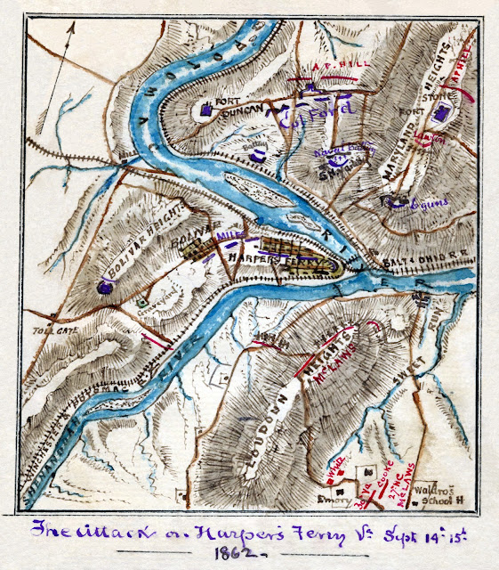
Obviously, this was a great location for moving supplies and munitions, as well as soldiers, to various locations in the US.  In the map below you can see three area heights look down on Harpers Ferry, Bolivar Heights, Loudoun Heights, and Maryland Heights.  Oh, I love maps!  You'll see several in this post.  


The Attack on Harpers Ferry, Sep. 14-15, 1862.
On this map, you can see the three heights labeled as well as the rivers and railroads.  Union troops are noted in blue off to the northeast, as well as at the armory and on Bolivar Heights.
  
Attack on Harper's Ferrypass5 - Battle of Harpers Ferry - Wikipedia

These surrounding mountains made Harpers Ferry extremely hard to defend and because of this, it changed hands several times during the war.  In fact, General "Stonewall" Jackson said he would rather capture Harpers Ferry 40 times than defend it once.  At this particular time of the war, the union army had a large supply hub here.  Lee knew he must take Harpers Ferry because of the large number of troops garrisoned there, and because taking Harpers Ferry and its large storage of supplies, would be a boost to the Southern Army. If he failed to take the armory, it would deal a huge blow to his Maryland Campaign. (3)


Top map, The Maryland Campaign, September 1862.  The Confederate movements are in red and the Union in blue.  The bottom map is not as busy as the top one and makes for a better read for me.
By Hal Jespersen at en.Wikipedia - http://www.posix.com/CWmaps/Maryland_Campaign.png, Public Domain, https://commons.wikimedia.org/w/index.php?curid=2000665
Bottom map, Invasion of Maryland.
By United States Army Center of Military History - Perry D. Jamieson and Bradford A. Wineman, The Maryland and Fredericksburg Campaigns, 1862–1863. Washington, DC: United States Army Center of Military History, 2015. CMH Pub 75-6., Public Domain, https://commons.wikimedia.org/w/index.php?curid=49150547

If you have read about the Maryland Campaign you will probably remember what happens next.  General Lee wrote orders for his plan to take Harpers Ferry and his plan to invade the North.  He would use the destruction of Harpers Ferry, and the vital supply lines of the Union Army, as a springboard to invade the north, and eventually capture Washington DC.  The orders were "Special Orders 191".  These orders outlined General Lee's detailed plans for "ambitious simultaneous convergences by widely separated columns upon an assigned objective."  "Low-lying Harpers Ferry, more trap than a fortress, was dominated by heights that frowned down from three directions."  General "Stonewall" Jackson, who had been in command of Harpers Ferry the year before and knew the area well, was to be in charge of the operation. (4)


General Thomas J. "Stonewall" Jackson
By Unknown author - Derivative (crop) of File: Photograph of General Thomas J.; "Stonewall"; Jackson - NARA - 526067.tif, Public Domain, https://commons.wikimedia.org/w/index.php?curid=4949147

 Jackson would "move with his three divisions through Boonsboro to the vicinity of Williamsport, where he would cross the Potomac and descend on Martinsburg, capturing the garrison there or driving it eastward to Harpers Ferry, where he would occupy Bolivar Heights, McLaws, with his own and Anderson's divisions, would move southwest and take a position on Mayland Heights, Walker would move south with his two-brigade division, cross the Potomac below Point of Rocks, and occupy Loudoun Heights". (5) Thus surrounded it was expected the Union garrison would not be able to hold out long.

Longstreet, for his part, would move westward and occupy Boonsboro, supported by D.H. Hill.  All movements were to begin Sep. 10th and the three Generals were to converge on Harpers Ferry on the 12th or 13th at the latest.  Once Harpers Ferry was defeated the three generals were to rejoin Lee's main body at Boonsboro, where Lee would continue through Maryland and into Pennsylvania. (6)

The orders went out to the generals and their staff.  They in turn, once the plans were read and understood, were supposed to burn or destroy the orders.  Unfortunately, the copy of the orders that went out to General D.H. Hill did not suffer the firey end it was supposed to.  One of the staff officers, instead of destroying the copy, decided he would keep the orders as a souvenir.  He used the orders to wrap around three cigars and stuffed them in his pocket. (7)

General Lee, proceeding with his Maryland Campaign, led his army through the little town of Fredrick, Virginia, (As you can see on the maps above, in the upper-middle portions of the maps.)  and then headed toward South Mountain, and on through Turner's Gap.  The final, grand act of Lee's astonishing plan was to take his united army to Harrisburg, Pennsylvania.  The importance of this town was based on the Pennsylvania Railroad that crossed the Susquehanna River at this location. "That is the objective point of the campaign," Lee explained. Destruction of the bridge there, supplementing the previous seizure of the B & O crossing at Harpers Ferry and the wrecking of the Monocacy aqueduct of the Chesapeake & Ohio Canal - this last would be done by Walker, in accordance with instructions already given him, on the way to point of Rocks - would isolate the Federal East from the Federal West, preventing the arrival of reinforcements for McClellan except by the slow and circuitous Great Lakes route.  "After that," Lee concluded, 'I can turn my attention to Philadelphia, Baltimore, or Washington, as may seem best for our interest.'  The war would be over - won." (8)

As Lee moved north, McClellan's troops were not far behind, only a couple days.  In fact, they stopped to make camp in Frederick, Maryland, exactly where the Confederate army had just been.  Two Union soldiers, Private B. W. Mitchell and Sergeant J. M. Bloss, Company E, 27th Indiana, upon the order to stack arms and take a break, were lounging in the grass near Frederick when they made an exciting discovery, free cigars!  To their astonishment and delight, lying on the ground wrapped in paper, were three cigars.  Their good fortune quickly took an even more fortuitous turn for the Northern Army upon their recognizing the simple paper wrapped around the cigars was actually Confederate orders.  Oh, yes, of course, those were "Special Orders 191". (9)


Special Orders 191. One Copy of the orders is now located in a museum at Crampton's Gap, Maryland.
Special orders 191 By Wilson44691 - Own work, CC BY-SA 3.0, https://commons.wikimedia.org/w/index.php?curid=17489610

Obviously, these Confederate orders, General Lee's orders, no less, quickly found their way to General McClellan, commander of the Union forces.  McClellan now knew exactly where Lee was going and exactly how he planned to carry out his invasion of the North.  McClellan began to act on his extreme good fortune.  Who could know what this stroke of good luck could do for the Northern Army?  By knowing in advance what Lee was going to do, McClellan would be able to destroy Lee's army and most likely bring this terrible war to a quick end.

"Here is a paper with which, if I cannot whip Bobby Lee, I will be willing to go home."    General George B. McClellan (10)

Remember that the Civil War did not end until 1865.  This was September of 1862.  Just think of the lives that would have been saved if McClellan had broken Lee at this point in the war.

But McCellan's dream was not to be.  As fate would have it, on the occasion of McClellan's receiving the lost "Special Orders 191", there happened to be a Maryland citizen with southern sympathies at McClellan's headquarters.  Upon hearing what had happened he made a mad dash to Jeb Stuart's line and gave him the news, Stuart then passed it on to General Lee. (11) 

Now, with the knowledge that McClellan knew of his original plans, Lee was able to at least try and mitigate the effects of this knowledge.  But still, Lee was now on the defensive, rather than the offensive, and certainly, the surprise element of his plan was out the window.  He could revise his plans somewhat, but the whole of the Maryland Campaign now seemed in doubt.

On his way to Boonsboro, Lee deployed D. H. Hill at Turner's Gap to protect the rear from any approaching Union Forces.  Now that Lee knew McClellan had the orders, he knew he would be coming with his entire army, so he had to do something to keep Hill from being overwhelmed.  He immediately sent word to Hill at Turner's Gap with the news of the lost orders and implored him to hold as long as possible.  If the Union Army came swarming through Turner's Gap and descended on Harpers Ferry his entire army would be endangered.  He just needed Hill to give him enough time to take down Harpers Ferry, but he knew Hill could not do this alone, so at the same time, he ordered General Longstreet to hurry to Turner's Gap to reinforce Hill. (12) 


Battle at South Mountain, Maryland.
South Mountain - Fox's and Turner's Gap - Evening Fighting - September 14, 1862,| American Battlefield Trust (battlefields.org)

Lee was right to be worried.  Hill fought admirably but eventually started to be pushed back and was on the verge of being routed when Longstreet's army arrived.  Longstreet quickly sent his troops forward to shore up Hill's faltering lines.  Fortunately for Lee, they were able to stabilize the situation until darkness, and both sides made camp for the night. This was the evening of Sep 14, 1862. There were 1800 casualties on each side with an additional 800 Confederates captured at South Mountain. Meanwhile, events were unfolding at Harpers Ferry. (13)


Lieutenant Colonel Ruther B. Hayes of the 23rd Ohio in the Civil War.
By Unknown artist - Rutherford Hayes Presidential Center, Public Domain, https://commons.wikimedia.org/w/index.php?curid=11073403
Hayes Civil War - Rutherford B. Hayes - Wikipedia

An interesting footnote to history.  Amongst the Union forces fighting at Turner's Gap that day was Lieutenant Colonel Rutherford B. Hayes of the 23d Ohio. Hayes was wounded but he would recover and go on to become the 19th President of the United States fifteen years later.  For another Union soldier, Sergeant William McKinley, no bullets would find him that day, but unfortunately, his destiny did include a bullet that would find him almost forty years later while serving his second term as the 25th President of the United States.  That bullet was fatal and Vice President Theodore Roosevelt became the 26th president.  Also, there was General McClellan, who would soon be booted out as General of the Union Army.  He would run an unsuccessful campaign for president against Abraham Lincoln in 1864. (14)


William McKinley in 1865.
By Matthew Brady; Major McKinley: William McKinley and the Civil War; by William Armstrong (2000), but previously published at least as early as 1901 in; The life of William McKinley; by Oscar King Davis and John Kimberly Mumford -- see here, p. 4., Public Domain, https://commons.wikimedia.org/w/index.php?curid=18558013, McKinley Brady_1865.png (861×1238) (wikimedia.org)

You may need to refer back to the Maryland Campaign map, below so that you can trace the paths of the armies.


Invasion of Maryland.  You can see the red lines on the map indicating Walker's position to the southeast, McLaws (along with Anderson), to the Northeast, and Jackson, to the southwest. They have Harpers Ferry surrounded.
By United States Army Center of Military History - Perry D. Jamieson and Bradford A. Wineman, The Maryland and Fredericksburg Campaigns, 1862–1863. Washington, DC: United States Army Center of Military History, 2015. CMH Pub 75-6., Public Domain, https://commons.wikimedia.org/w/index.php?curid=49150547

Upon arrival on the 13th, the first order of business for McLaws was to dislodge the Union forces occupying Maryland Heights.  This objective was accomplished and on the morning of the 14th, McLaws, and the main body of his troops (including Robert and Thomas Armistead), set up on Maryland Heights, with his artillery aimed at Harpers Ferry.  At the same time, he was preparing for the attack on Maryland Heights, he deployed three brigades to his rear in the direction of South Mountain to protect from any rearguard action by Union forces.  General Walker also moved his artillery into place on Loudoun Heights.  Jackson was maneuvering around Bolivar Heights to place his artillery at Schoolhouse Ridge.  As soon as all the artillery was in place they would begin bombardment.


Major General Lafayette McLaws.
By Uncredited; lightly restored by Adam Cuerden - This image is available from the United States Library of Congress; Prints and Photographs division under the digital ID cph.3a00276.This tag does not indicate the copyright status of the attached work. A normal copyright tag is still required. See Commons: Licensing for more information., Public Domain, https://commons.wikimedia.org/w/index.php?curid=35433732


Major General Richard H Anderson
By Courtesy Century Co. - https://archive.org/stream/lifeoflieutenant01walk#page/n9/mode/2up, 
Public Domain, https://commons.wikimedia.org/w/index.php?curid=68956277

During the night of the 13th, from inside Harpers Ferry, Union Colonel Dixon Miles ordered Captain Charles H. Russell to sneak through enemy lines and get a message to General McClellan, that he could only hold out 48 hours and must have relief.  Russell made it to McClellan and McClellan ordered an entire corps to march through Crampton's Gap to relieve Harpers Ferry.  He sent three messengers back to Miles to let him know help was on the way, but none of the messengers made it back to Miles. (15)

On the morning of the 14th,  General Jackson knew he had Harpers Ferry in a desperate position.  However, he also knew he was a day behind the schedule set out in "Special Order 191" and he knew that General Lee's army was dangerously divided across Maryland and Virginia.  What he did not know would have worried him even more.  "Portions of McClellan's 75,000 man army were already in the Middletown Valley and heading toward South Mountain". (16) 

As mentioned before, D.H. Hill was defending at Turner's Gap on the day of the 14th, and McClaws, stationed on the Maryland Heights, could hear the rumbling sounds of battle rolling along South Mountain. He was not worried by the distant sounds or at least not until they were no longer distant.  The battle sounds were getting closer and louder.  At first, he was told, and as he suspected, the louder sounds were from his rearguard engaging with a brigade of Union troops.  He was not worried at first, but then the  noise grew louder and McClaws decided he had better take a look at the situation in person.  Upon arrival he found his men breaking in panic and fleeing.  It turns out it was not a brigade but Major General William B Franklin's VI corps that had come down through Crampton Gap, sent by McClellan to relieve Harpers Ferry.   

McLaws was able to rally his troops and get them turned and back in line.  They had performed well in holding the line but had finally been overwhelmed.  He quickly brought up three more brigades from the heights to help set up a line a couple miles south of Crampton Gap.  Franklin did not push the advantage and settled down for the night.  Lee was fortunate Franklin demurred.  Had Franklin pressed his advantage when he had it, he might have been able to disrupt Jackson's assault on Harpers Ferry.   

Lieutenant Anthony Armistead and his brother Thomas Stewart Armistead were serving in the 8th Florida Infantry that was under Richard H Anderson's division, so I think they probably remained on the Maryland Heights while McClaws most likely would have used his own brigades in the rearguard action. But they probably took part in the assault on Maryland Heights on the 13th. 

Meanwhile, at 2:00 pm on the 14th, Jackson signaled the start of the artillery bombardment of Harpers Ferry from all sides.  For four and a half hours the bombardment continued.  Harpers Ferry did not fall. (17)


Siege of Harpers Ferry
By William MacLeod - This file was donated to Wikimedia Commons as part of a project by the National Gallery of Art. Please see the Gallery's; Open Access Policy., CC0, https://commons.wikimedia.org/w/index.php?curid=81333620

During the night of the 14th, 1400 cavalrymen and their horses unbelievably escaped from Harpers Ferry, a place that was surrounded by Confederate soldiers.  At 8:00 am the next morning the Confederate Army commenced firing again.  What little morale that was left in the Union Infantry quickly evaporated when they found that they were not only surrounded, and out of any long-range ammunition for their batteries, but they had also been abandoned by the calvary.  

Within Harpers Ferry, the leaders decided to surrender.  "The Harpers Ferry Garrison lost 44 killed, 173 wounded and an astounding 12,737 men captured, along with 73 artillery guns, 13,000 small arms, and 200 wagons.  It remained the largest surrender of U.S. troops until Bataan in 1942." (18)

In war, you never have time to savor the victory or grieve the losses.  Lee and Longstreet were at Sharpsburg and Lee needed desperately to get his divided army back together.  If McClellan could move into the gaps and cut off pieces of Lee's army or attack Lee's troops at Sharpsburg, the Army of Northern Virginia would be in grave danger. The first order of business for Jackson was to get to Sharpsburg, where Lee and Longstreet had set up a line of defense.  Walker's division crossed the Shenandoah and followed Jackson to Sharpsburg.  McLaws and Anderson began crossing the Potomac to begin their march to Sharpsburg.  General A.P. Hills Divison was left at Harpers Ferry to confiscate all the provisions, munitions, and anything of value, that he could, and then to parole the Union soldiers.  This meant he would be the last to come up to rejoin the main body of Lee's army.

Jackson and Walker reached Sharpsburg on the 16th following a forced march from Harpers Ferry.  Lee had built his meager defense on the high ground between Sharpsburg and Antietam Creek and had each end of his line anchored on the Potomac River to prevent being flanked.  These new arrivals brought his total number of soldiers to 26,000.  McClellan's army had over 70,000 troops.  If McClellan attacked Lee with his 3-1 advantage Lee would most likely have been overwhelmed.  Even if McLaws and Anderson's divisions arrived in time, along with A.P. Hill's Division, which was still at Harpers Ferry, Lee would still be outnumbered 2-1. (19)


Map of the Battlefield of Antietam.  Note that in this map the blue lines are Confederate and the red lines are Union.
Map of the battlefield of Antietam | American Battlefield Trust (battlefields.org)https://www.battlefields.org/learn/maps/map-battlefield-antietam prepared by Lieut. Wm. H. Willcox, Top. Off. & A.A.D.C. on Brig. Genl. Doubleday's staff. [Sept. 17, 1862].

On Sep16, 1862 Lee dispatched a courier to A.P. Hill telling him to come up at all possible speed.  Although Lee had an inferior number of troops and didn't even have all of those with him, Lee still had his plan laid out and from all indications, he and his generals were relaxed and confident.  

General McClellan, approaching Sharpsburg with at least twice as many troops, believed that he finally had Lee in an inferior position and was confident of a significant victory.  

Of course, neither of them knew what was really going to happen.  What did happen was Sep. 17, 1862, the "Bloodiest Day in American History"! (20)

References:
1) Kunkel, Jack, Showdown at Antietam, A Battlefield Tour of America's Bloodiest Day in American History, Pepper Publishing and Pepper Studios, Copyright 2013, pg 202.
2) Ibid, pg 202.
3) Ibid, pg 202
4) Foote, Shelby, The Civil War, A Narrative, Fort Sumter to Perryville, Random House, New York, Copyright 1958, pg 667.
5) Ibid.
6) Ibid, pg 668.
7) Ibid.
8) Ibid, pg 668-669.
9) Ibid.
10) Ibid, pg 671.
11) Ibid, pg 675-676.
12) Ibid, 
13) Ibid, pg 677.
14) Ibid.
15) Kunkel, Jack, Ibid, pg 208.
(16) Ibid.
(17) Ibid.
(18) Ibid, pg 209-210
(19) Foote, Shelby, Ibid, pg 681-682.
(20) Kunkel, Jack, Showdown at Antietam, A Battlefield Tour of America's Bloodiest Day in American History, Pepper Publishing and Pepper Studios, Copyright 2013, Quote from the title of the Book.


Friday, June 18, 2021

Armistead Family History #22

               1862 - Armistead Family in the Civil War


By the close of 1861, the Civil War's violent and deadly clashes had reached across the United States.  North, South, East, West, as well as down the Gulf Coast, and the central states along the Mississippi River.  Battles were occurring all over and increasing in size and frequency.


Battles of the American Civil War.   https://en.wikipedia.org/wiki/List_of_American_Civil_War_battles#/media/File:American_Civil_War_Battles_by_Theater,_Year.png
Public Domain, https://commons.wikimedia.org/w/index.php?curid=35637

You may remember from an earlier blog post that the population of the US was growing rapidly and expanding Westward across the continent.  In 1860 the population was 31,443,321, spread over 44 states from Maine to Florida, Virginia and North Carolina to Missouri, Arkansas, and Texas, and even to California.

To give you a better picture of how the population was actually located though, let's look at the breakdown between North and South, defined by the two sides in the Civil War.  The Northern states (33) had a population of 22,339,989.  The Southern states (11) had a population of 9,103,332.  That's a big difference in manpower, however, the difference was even greater than that, because out of the total population in the south, 3,521,110 were held as slaves.  This leaves a population of about 5.6 million for the south and 22.3 million for the north.  Looking at these numbers alone, the end just seems so inevitable.  Manpower, railroads, access to goods, manufacturing, were all lopsided in favor of the North. (1)

Still, the people of the South thought they would defeat the North and with the arrival of  January 1, 1862, after a year of bloody fighting, their opinion had not changed.  But I do think both sides realized the war would not be quick or easy.   

There were many battles and skirmishes in 1861.  Civil War Saga's website - Civil War Battles (civilwarsaga.com) - lists ten major battles during 1861, including the First Battle of Bull Run/First Battle of Manassas, (4,878 casualties), Wilson's Creek, (2,330), Battle of Dranesville (5,750), and others.  This website is an excellent source for information on battles of the Civil War.

The Armistead and Baker families survived 1861, even though they had at least  10 family members enlisted and fighting.  This number included William Jordan Armistead, Sr., George Franklin Baltzell, and Simmons Jones Baker, Jr.  I did not mention these men in my last blog.  They were of the older generation and did not figure prominently in any fighting, but they were listed as members of the Jackson Home Guard from Sep. 1861 to sometime in 1862 when it was disbanded.  This was a cavalry group from Marianna and the surrounding area.  It was held on standby, as a last resort against the invasion of Union forces. (See Dale Cox's list below).


Jackson Home Guard.  
Dale Cox, The History of Jackson County, The Civil War Years.

When April, 1862 arrived, the one-year enlistments of the Armisteads and Bakers ended.  They re-enlisted but in different units from what they were in previously.  William Jordan Armistead, Jr. transferred to Richard L. Smith's Company, known as the Marianna Dragoons Calvary.  Anthony Armistead enlisted in Company E, of the 8th Florida Infantry.  He was soon promoted to 2nd Lieutenant.  His brother, Lawrence Turner Armistead, did not go with his brother this time. Instead, he signed up in Co E, of the 6th Florida Infantry. He too would be appointed as a Lieutenant.  Their cousin, Henry Hyer Baker, signed up with Co A, 33th Regiment, North Carolina Infantry.  He was promoted to 1st lieutenant in October and would later become Captain. Beverly Baker went with his cousin, W.J. Armistead, Jr., and signed up with Captain Smith's Marianna Dragoons. (2)  

Marianna Dragoons Calvary  
Dale Cox, The History of Jackson County, The Civil War Years.

W.J. Armistead, Jr. and the others, mustered into Captain Richard Smith's Marianna Dragoons Cavalry in 1862 and were assigned as an independent company.  The company's responsibility was to protect Jackson County and the other counties of the Northern part of Florida.  At one point they were transferred from Jackson County to Pensacola in Escambia County, participating in skirmishes and battles across the northern part of the state.  

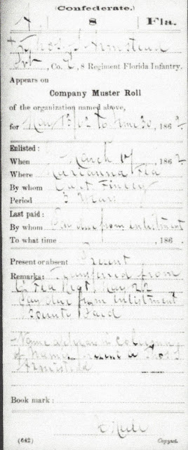
With the new year of 1862, other family members would reach an age that enabled them to enlist in the military as well.  Anthony's younger brother Thomas Stewart Armistead, (19) joined Anthony in Company E, as a 1st Sergent.  He would soon become a 3rd Lieutenant.  Beverly Baker's brother, Lawerence, (18) joined Lawerence in the Marianna Dragoons. (3)  


Sample of Thomas S. Armistead military record. NARA M251.  Compiled service records of Confederate soldiers from Florida units, labeled with each soldier's name, rank, and unit, with links to revealing documents about each soldier.
https://www.fold3.com/image/120589231

Another family enlistment in the Marianna Dragoons was George Albert Baltzell (17).  George was the son of George Franklin Baltzell and stepson of Ann Penelope (Armistead) Baltzell.  Ann was the eldest of W.J and Eliza's children.  There are other family members, cousins, etc., I am sure.  I have decided to limit the names a little.  (I expect many of you reading this are saying "He should learn how to limit a lot more than that!").  Well, I am afraid that I am not a good editor and so I tend to get too wordy.  I am giving you a fair warning, the posts on 1862 will be fairly long and will have a lot of battle information.  If you are not into that sort of thing, feel free to skip forward to the parts you are interested in.  But I feel it is important to go into some detail to try and give us a better understanding of how bad this terrible war was during this time.

From the website, Civil War Saga, I found information about the battles of 1862.  It lists Mill Springs, Jan 19, (814), Fort Henry Feb 6, (119) Fort Donelson, Feb11, (16,537), and Pea Ridge, Mar 6, (6,073) just to name a few in the first months of the year.  As a reminder causalities (listed in parenthesis) included: deaths, wounded, and captured.  Death counts after a battle were not actually accurate because death caused by the fighting continued for days, weeks, maybe years.  The effects of amputations, wounds that didn't heal, gangrene, pneumonia, bullets and shrapnel that could not be removed, etc., caused numerous deaths long after the battle ended.


Battle of Shiloh.
By Thure de Thulstrup - This image is available from the United States Library of Congress's Prints and Photographs division under the digital ID pga.04037.This tag does not indicate the copyright status of the attached work. A normal copyright tag is still required. See Commons: Licensing for more information., Public Domain, https://commons.wikimedia.org/w/index.php?curid=69199332

On April 6-7th, the Battle of Shiloh was fought, resulting in a Union victory.  The actual victor of any battle was illusory, however.  Casualties were 13,047 for the Union forces and 10,699 for the Confederates and then both armies just moved on to fight again another day. (4)  None of the family members I mentioned above were involved at Shiloh (due to enlistments ending and re-enlisting, or not being in a unit sent to that theater of the war).  

Lawrence T. Armistead and the 6th Florida, commanded by Colonel Jesse J. Finley, were ordered to report to General E. Kirby Smith at Knoxville.  Smith was the Commander of the Department of East Tennessee and participated in the Kentucky Campaign.  The 6th, under Finley, was ordered by Kirby to occupy and defend the Cumberland Gap against a possible approach by Northern forces.  General Smith meanwhile moved north and won a decisive battle at Richmond, Kentucky.  He next marched into Lexington, Ky to hold the line against the approaching Northern forces.  After a month-long siege by Colonel Finley and the Confederates against the Federals at Cumberland Gap, the Federals blew up or set fire to their stores of ammunition and arms and escaped to the Ohio River.  Colonel Finley and the 6th Florida then reunited with General Kirby at Lexington, Ky. (5)

The Kentucky Campaign.By Map by Hal Jespersen, www.cwmaps.com, CC BY 3.0,           https://commons.wikimedia.org/w/index.php?curid=17811337

The Kentucky Campaign ended with "General Bragg, (overall commander of the campaign), either retreating or withdrawing (there is disagreement on which) from Kentucky in front of the Union's General Buel."  The South had planned to force the neutral state of Kentucky to get involved on the Confederate side, or to at least recruit a substantial number of soldiers from the state.  They were not successful on either count. (6)  

Anthony, Thomas, and the 8th Florida Infantry, under command of Colonel R.F. Floyd, were sent to Virginia.  Along with the 2nd and 5th Florida, they were ordered to join General Robert E. Lee's Army of Northern Virginia.  These regiments were placed in Brigadier General Roger A. Pryor's Brigade, Major General Richard H. Anderson's Division under Major General James Longstreet's command.  Henry Hyer Baker's company, Co. A, in the 33rd North Carolina Infantry Regiment,  under Brigadier General L. O'Brian Branch's Brigade, in A.P. Hill's Division, and under command of Major General Thomas J. (Stonewall) Jackson, was also a part of Lee's army. (7) 

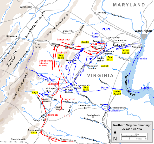
In July, August, and September, General Lee's Army of Northern Virginia executed the Maryland Campaign.  In mid-July 1862 they fought a battle near Sharpsburg, Maryland at the opening of the Maryland Campaign.  In August Lee found Union General Pope, with a larger force than his, in his way.  Lee decided to split his army and have General Longstreet hold the position he had taken right in front of Pope, and have Stonewall Jackson swing around Pope's right flank and destroy Pope's supply lines in his rear.  He was not to engage in battle but to burn bridges, destroy railways, etc., and then to meet up with Longstreet in the vicinity of Manassas where Lee would take advantage of whatever opening Pope might give up. (8)  See the map below for movements of both armies during August in Northern Virginia. 


By Map by Hal Jespersen, www.posix.com/CW, CC BY 3.0, https://commons.wikimedia.org/w/index.php?curid=7100910

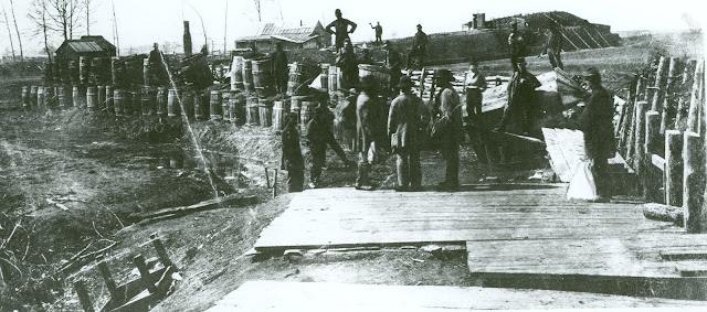
By late August, Jackson's troops had marched behind the Bull Run Mountains, through Thoroughfare Gap, and had moved on past Hay Market.  Traveling south-southeast from there led him to Gainesville, then across the Warrenton Turnpike, and on to Bristoe Station.  At Bristoe Station Jackson's men overwhelmed the few startled guards that were there and set about dismantling train tracks, and causing several trains to wreck.  The Broad Run railroad bridge was destroyed next and then it was time to head to Manassas.  His troops were weary but Jackson knew he must get to Manassas before Pope could send troops to reinforce the town and most importantly the supply depot there.   He left two brigades to guard the Broad Run crossing (at Bristoe Station on the map) in his rear and moved on with the rest of his troops to Manassas. (9)  

By ManassasNPS - Manassas Junction3 1862Uploaded by AlbertHerring, CC BY 2.0, https://commons.wikimedia.org/w/index.php?curid=29594683

Here is how Shelby Foote described it when they arrived at Manassas Station: "The sight that awaited them there was past the imagining of Stonewall's famished tatterdemalions.  Acres - a square mile, in fact - of supplies of every description were stacked in overwhelming abundance..."  "...warehouses overflowed with rations, quartermaster goods, and ordnance stores."  They found everything from molasses, coffee, cigars, jackknives, writing paper, handkerchiefs, whiskey, (but Jackson ordered these barrels destroyed) loaves of light-bread, pickled oysters, canned lobster, and Rhine wine. (10)

As Jackson's men were gorging themselves, Union Brigadier General George W. Taylor and a brigade of four New Jersey regiments were sent down from Alexandria with orders to save the railroad bridge.  Instead of stopping at the bridge, they rushed forward to attack the confederate force that was thought to be just a cavalry unit.  Little did they know they were running straight into General Lee's largest and probably hardest fighting division in Lee's whole army.  The union forces pushed forward under fire, determined to drive this force out.  But Jackson unleashed his full force against the oncoming "Jerseymen".  "..it was as if they struck a trip-wire.  Suddenly demoralized, they turned and scampered, devil-take-the-hindmost."  (11)

Jackson burned the railroad bridge and loaded the ambulances and ordnance wagons - all the rolling stock he had - with Federal stores that were most needed, mainly medical supplies.  Then once again the men were allowed to recover whatever food, etc. they could.  Jackson received word his troops were under attack at Bristoe and realized it was time to fall back to a position of strength and wait for the arrival of Longstreet and the rest of Lee's army.  The remaining ammunition dumps were exploded, warehouses and train cars were burned.  Then Jackson and his men slipped away. (12)

When General Pope and his men reached Manassas, all they saw was wreckage and desolation.  Jackson was nowhere to be seen and they were unsure as to what direction he might have gone.  Pope's big fear was that Jackson would be able to escape his grasp and rejoin Longstreet, who he knew would be moving to meet up with Jackson.  Pope was not in the dark for long.  Late that evening he received two dispatches.  One telling him Longstreet was forced back to the west side of Bull Run Mountain and that Jackson had been found in the woods along the Warrenton Turnpike.  He had Jackson isolated from Longstreet and, with his greatly overpowering numbers, he could crush Jackson's army, once and for all. (13)


Jackson's Troops location (in red) on Aug. 28, 1862.

By Hal Jespersen, www.CWmaps.com/, CC BY 3.0, https://commons.wikimedia.org/w/index.php?curid=9064179

It turns out General Pope had underestimated his adversary.  Jackson was not trapped, and he was not trying to escape as Pope thought.  After burning the stores at Manassas, Jackson had deliberately headed out for Groveton, located on the Warrenton Turnpike.  Jackson, having spent time in the area the year before, knew the lay of the land and the most advantageous place to set up a defensive position.  His destination was an excellent covered position where he could wait for Longstreet, or if forced out by Pope, he had a line of retreat that would be reasonably secure. (14)

Jackson stationed his troops in the woods along the Warrenton Turnpike.  He was soon notified of Federal forces moving up the pike heading toward Stone Bridge.  This was John Gibbons's brigade of four regiments under Pope's command.  Waiting for the best moment to strike, Jackson waited until the Union troops were in front of his position, before giving his order to strike.  Artillery and infantry emerged from the woods with a deafening roar.  The two armies slugged it out for two hours in extremely hard-fought, close-quarter fighting.  About 9:00 pm the Federals withdrew across the Warrenton Pike.  After conferring, the Union leaders decided to head with their wounded down to Manassas. (15)


Confederate and Union Positions on August 29, 1862.  
By Map by Hal Jespersen, www.CWmaps.com, CC BY 3.0, https://commons.wikimedia.org/w/index.php?curid=7104342

The next day Jackson positioned his troops behind the high grade of an unfinished railroad, which afforded his men excellent defensive positions to take on any incoming attacks.  Jackson poured artillery fire into Pope's men's position located on the other side of the unfinished railroad.  Around 10:00 am one of Longstreet's divisions arrived on the scene as Lee's army was beginning to reunite, but all of the units were not yet up.  As they arrived, Longstreet's men were deployed straddling the Warrenton Turnpike. 

Pope, ignoring Longstreet's arrival, continued focusing on Jackson.  He was so intent on crushing Jackson with his superior numbers, he seemed to block out Longstreet's arrival and positioning off of his left flank.  Pope promptly sent wave after wave of his troops against Jackson's position behind the berm along the railroad.  At times it seemed a portion of Jackson's line would be overwhelmed, but the Federals were repulsed each time.  Jackson suffered a large number of casualties but somehow was able to hold the line. (16)

On the map below locate the bottom right panel.  This panel shows the early movements of the two armies leading up to this battle.  Then move to the upper left panel and you can see in the upper-middle portion the red lines of Jackson's position to the northwest of the railroad line.  The final panel in the upper right shows the positioning on Aug 29th and 30th of Jackson, Pope, and Longstreet.  

https://commons.wikimedia.org/wiki/File:WPMA01_Second_Bull_Run_Campaign.jpg#/media/File:WPMA01_Second_Bull_Run_Campaign.jpg

Once most of Longstreet's forces were up, Lee conferred with Longstreet about attacking Pope's left flank.  Longstreet was cautious, waiting for Anderson's Division. This was Thomas and Anthony Armistead's division.  They had been left protecting the rearguard so it was the last to come up.  He also told Lee he needed to check out the lay of the land and make sure he was aware of the situation before ordering his troops to move. (17)    

Anderson finally arrived on the scene with the main body of his army. Lee directed General Longstreet to move into position along Jackson's right flank, which would be just to Pope's left.  As mentioned, Pope had inflicted heavy casualties on Jackson and Pope had a much larger force.  On Aug 30th, Pope thought the time was right to make an all-out assault on Jackson, overrun his position, and crush him.  Again, ignoring Longstreet, the assault on Jackson's position began around 2 pm.  This was exactly what Longstreet was hoping would happen.  After Pope's attack began, Longstreet smashed into Pope's left flank.  With Jackson in front and Longstreet on the left, Pope was smack in the middle of a pincher-like movement by Lee's army that soon crushed Pope's army.  Pope's army eventually withdrew to the north across Stone Bridge, blowing it up, after they crossed. (18) This time the withdrawal was not as panicked as the disastrous retreat from the First Battle of Bull Run/First Battle of Manassas had been a year ago, but it was a major defeat for the Union Army nonetheless.

Union Retreat across the Stone Bridge.  By Rufus Fairchild Zogbaum - This file is from the Mechanical Curator collection, a set of over 1 million images scanned from out-of-copyright books and released to Flickr Commons by the British Library.View image on FlickrView all images from book View catalog entry for book., Public Domain, https://commons.wikimedia.org/w/index.php?curid=60711156


Stone Bridge destroyed by Union troops after retreat.
By George N. Barnard - U.S. National Archives and Records Administration, Public Domain, https://commons.wikimedia.org/w/index.php?curid=16896858

So here, on the plains of Manassas, a year after the first, the Second Battle of Bull Run/Second Battle of Manassas was fought.  Pope suffered 13,824 casualties (62% of the total) and Lee 8,353. 

As Pope retreated Lee moved his army further into Maryland to continue his Maryland Campaign.  His plan was to clear out any Union forces on his way deep into the north, as far as Washington DC if possible.  This could be a disruptive and devastating blow to the North.  Harper's Ferry was one of those places where he wanted to clear out the Union forces.

Anthony Armistead, Thomas Armistead, and Hyer Baker saw heavy fighting during the battle at Manassas/Bull Run and survived.  What would the future hold?  Well, they will soon be fighting again, at Harper's Ferry.

References:
(2) National Park Service. U.S., Civil War Soldiers, 1861-1865 [database on-line]. Provo, UT, USA: Ancestry.com Operations Inc, 2007., Original data: National Park Service, Civil War Soldiers and Sailors System, online <http://www.itd.nps.gov/cwss/>, acquired 2007.
(3) Source Citation: Historical Data Systems, Inc.; Duxbury, MA 02331; American Civil War Research Database, Source Information: Historical Data Systems, comp. U.S., Civil War Soldier Records and Profiles, 1861-1865 [database on-line]. Provo, UT, USA: Ancestry.com Operations Inc, 2009.

Copyright 1997-2009, Historical Data Systems, Inc., PO Box 35, Duxbury, MA 02331.

(5) Historical Data Systems, comp. U.S., American Civil War Regiments, 1861-1866 [database on-line]. Provo, UT, USA: Ancestry.com Operations Inc, 1999, Original data: Data compiled by Historical Data Systems of Kingston, MA from the following list of works. Copyright 1997-2000, Historical Data Systems, Inc., PO Box 35, Duxbury, MA 023.
(6) Historical Data Systems, comp. U.S., American Civil War Regiments, 1861-1866 [database on-line]. Provo, UT, USA: Ancestry.com Operations Inc, 1999, Original data: Data compiled by Historical Data Systems of Kingston, MA from the following list of works. Copyright 1997-2000, Historical Data Systems, Inc., PO Box 35, Duxbury, MA 023.
(7) Historical Data Systems, comp. U.S., American Civil War Regiments, 1861-1866 [database on-line]. Provo, UT, USA: Ancestry.com Operations Inc, 1999, Original data: Data compiled by Historical Data Systems of Kingston, MA from the following list of works. Copyright 1997-2000, Historical Data Systems, Inc., PO Box 35, Duxbury, MA 023, 
(8) Foot, Shelby, The Civil War, A Narrative, Fort Sumter to Perryville, Random House, New York, Copyright 1958. pg 616.
(9) Ibid, pg 617
(10) Ibid, pg 618-619.
(11) Ibid, pg 619.
(12) Ibid, pg 620-621.
(13) Ibid, pg 623
(14) Ibid, pg 624.
(15) Ibid, pg 625-626.
(16) Ibid, pg 631.
(17) Ibid, pg 631.
(18) Ibid, pg 638.